Valley of Flowers Trek About Valley of Flowers The Valley of Flowers lives up to its name, with an endless supply of flowers in full bloom. The journey could even be renamed a floral fairytale romance! The Valley of Flowers' unique landscape is like a dream come true: an exquisite valley bejewelled with a never-ending stretch of flowers. Between the rocky mountain ranges of Zanskar and the Great Himalayas are lovely meadows studded with indigenous alpine flora. The area, which is a UNESCO World Heritage site, was designated as a national park in 1982. The endless stretch of gorgeous vegetation, dotted with colourful blossoms of pink, yellow, purple, red, blue, and orange hues, is the highlight of this excursion. Throughout the hike, the fragrant scent of the carpeting flowers entices you. Botanists, flower lovers, bird watchers, wildlife photographers, hikers, environment enthusiasts, and adventure seekers from all over the world are drawn to the valley's unspoiled beauty. It...
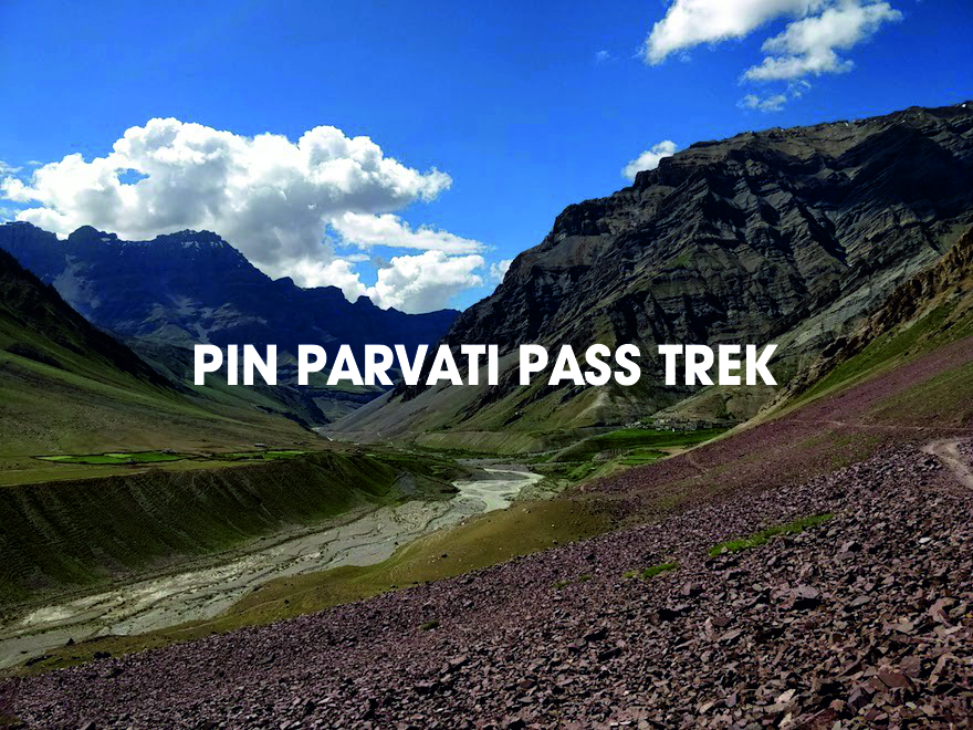
Pin Parvati Pass Trek, Himachal Pradesh
Are you a storyteller looking for inspiration, or a seasoned trekker looking for a hair-raising, eye-popping adventure?
So, how about a massive 17,457 ft pass at an altitude of 5,319 metres closer to the sky, nuanced with a shifting panorama of the lush prairies of Parvati Valley on one end of the spectrum and Buddhist hamlets in the wintry dry desert of the Trans-Himalayan region of Spiti on the other, painting a mural of lush geography with an assortment of vivid culture and diverse flora and fauna?
Do you come from a generation that has lost touch with the taste of pure water? Do you want to hop through the Pin Valley's peas and barley terraced fields? Perhaps the luminescent moorlands of Spiti are the missing pages in your storey! Who knows, you might find your adventure, a companion, or even a storey worth telling while dangling from the pulley bridge at Tunda Bhuj, attempting your way out of the quagmire of Mantalai swamps, gasping at the colossal pastures of Odi Thach, savouring hermitage in the dense forests near Kheerganga, and freezing at the glacier near the Pass.
The relaxing dip of numb feet in the hot springs at Parvati Kund in Kheerganga warms you up against the chilly glacier and seals the joyful experience in you. What a relaxing last lapse! The sweet fragrance of Losar and Brahmakamal flowers follows you home and lingers to leave you with a lasting smile.
U CAN ALSO READ THE KEDAR TAL TREK UTTARAKHAND AN AMAZING TREK
The 11-day adventure begins in Kullu, with a drive through the panoramic frame of dense alpine forests adorned with wildflowers, pristine lakes, wide glacier crests, and lavish meadows leading to Barsheni Village; the hot springs at Kheerganga, dedicated to Lord Shiva, warm the spiritual self, followed by a camp amidst tall Birch trees in the bowl of mountains, Tunda Bhuj. After a 5-hour journey, one arrives at the Kanawar Wild Life Sanctuary in Thakur Kuan. An 8-hour trek takes you to the Pin side base camp, which is located above the Pin Parvati Pass at a height of 17,500 feet.
Even the most experienced trekkers can be perplexed by the constant snowfall, monsoon rains, and ill-defined trails at higher altitudes. As one gets closer to Wichkurung Thatch, more caution is required. As one trek from Kaza to Manali for an overnight stay, the trek fades into 9 hours of picturesque hamlets. If you're interested enough to think about it, let's get to the modalities.
The Pin Parvati Pass trek is one of the most beautiful in the Himalayas. The trail takes you through lush green forests, wide open meadows, numerous waterfalls, a high altitude lake, and right up to the Parvati glacier. Only a few treks allow you to walk on a glacier, and the Pin Parvati trek is one of them. The transition to the contrasting Pin Valley in Spiti adds a cultural twist to the journey, making it even more appealing. The months of June to September are ideal for the Pin Parvati trek. It is a difficult trek that requires a lot of stamina and excellent trekking skills, and it is not recommended for beginners.

ALSO READ RUPIN PASS TREK THE MOST BEAUTIFUL TREK TO KNOW MORE CLICK HERE
If you are an experienced trekker looking for a thrilling adventure, the Pin Parvati trek is where you should go next. Continue reading for more information, such as the Pin Parvati Trek itinerary, temperature chart, photos, and videos. Scroll down to the bottom to read blogs about the Pin Parvati trek.
The Pin Parvati Pass trek is one of the most enthralling trans-Himalayan treks. This difficult and strenuous trail is ONLY for experienced and physically active hikers who have participated in high Himalayan multi-day camping treks at least twice, if not three times. Spiti's trans-Himalayan valleys were once difficult to reach, but the route through Pin Parvati pass cuts the distance between the Kullu and Spiti valleys in half. The trail was first opened to hikers in 1993. Despite the fact that the trek is strenuous and difficult, the beauty of the region makes it one of the most popular Trans-Himalayan treks.
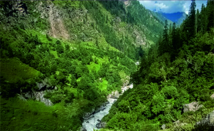
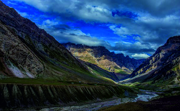
The trail is surrounded by lush green forest and mighty green valleys. The Pin Parvati Pass trek, an alternate route to the Spiti Valley in Himachal Pradesh, is one of India's most enthralling and difficult trekking trails.
During the trek to Pin Parvati camp, Mantalai, known for its age-old Lord Shiva temple and charming lake, serves as a cheerful host. Manali, which has a plethora of trekking options, comes up with the best in its arsenal, the Pin Parvati trek, which takes the trekker up to 17457 ft in elevation. This journey will take you to heaven and keep you from returning to your chaotic city life.

Kheer Ganga Trek Himachal Pradesh Explore the unseen trek
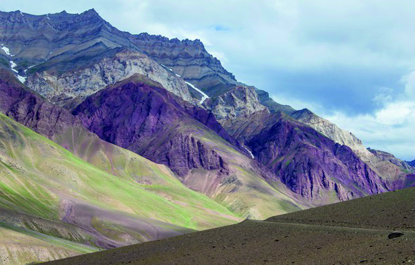
The bird's-eye view of the Parvati and Pin Valley is spectacular as you climb higher to Pin Parvati Pass.
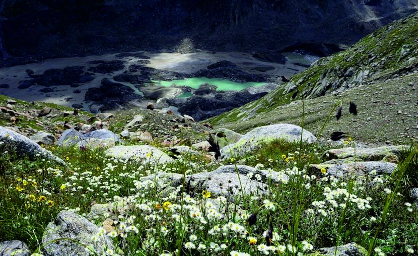
The pulley bridge at Tunda Bhuj, the marshlands of Mantalai, the alpine meadows of Odi Thach, dense forests near Kheerganga, and the glacier near the Pass are just a few of the unique experiences available at Pin Parvati. The Pin Parvati trek progresses from the cold dry deserts of Spiti and its unique settings to the lush, wet greenery of the Parvati valley. After days of trekking among wind-carved rock formations and glaciers, the greenery and flowers of Odi Thach hit you harder. Near the end of the trek, you can also visit the hot springs at Parvati Kund in Kheerganga. After a long day of trekking, nothing beats a hot water bath in this location. It's a five-star sauna experience on a trek, which is unusual for any Himalayan trek.
Pin Parvati Trek Best Time
This trail, like any other high altitude season, has two windows where you have a better chance of getting clearer and safer weather.
Pre-monsoon/Summer: From the third week of June to the end of August. The best time would be between the 20th of June and the 20th of July. The earlier you start, the more likely it is that snow will fall from lower altitudes, most likely in and around Mantalai Lake and above.
Post-monsoon/fall season: September to mid-October. Mid-October can be extremely cold, especially on the Spiti side. In addition, the likelihood of new snowfall increases in October.
The Most Beautiful Treks of Uttarakhand to know more click here
Pin Parvati Trek Difficulty / Challenges of Pin Parvati pass trek:
This trail contains a number of difficulties. To complete this difficult and strenuous trek, you must have a high level of physical and mental fitness in addition to prior high altitude trekking experience. It covers approximately 90 kilometres of trail and rucksack offloading is NOT permitted on this trek. This means that you must carry all of your personal belongings, as well as the sleeping bag in your rucksack throughout the trek. This keeps you safer on the trail in case of an unwelcome situation or if you become disoriented.
The route includes boulder and moraine stretches, icy cold river crossings, and a crevasse-filled glacier that circles the pass.
The trail has some tricky sections with potential exposures. There are two natural boulders on the river (one on the Parvati river called Pandu Pul / bridge, and the other on a side stream called Chhota Pandu Pul) that you must cross without a rope. There is plenty of friction on the rock, but you must remain calm and not panic.
Pin Parvati Trek Itinerary
Day 1: Drive from Kullu to Barsheni and Trek to Rudranath Camp Site.
The first day of the Pin Parvati Pass trek begins with a drive from Kullu to Barsheni Village, followed by a trek to the Rudranath campsite. You must arrive in Kullu a day ahead of time and spend the night there to rest for this first leg of your journey. So, as the trek begins with a drive from Kullu to Barsheni village, it takes you through some of the valley's most spectacular views.
The vehicle path to the village was recently laid. The journey to the village where the road ends would take about 4-5 hours. The tail begins from here on out. After a while, you'd arrive at Kagla Village, from where another half-hour trek would take you to Rudranath, your first camping spot. Along the way, you'd pass the confluence of the Tos and Parvati rivers and have to cross a bridge over the TOS.
This is followed by a path through the village dwellings and the township of Nakthan. Nakthan is reached after a fifteen-minute steep ascent and an hour of level walking. You'd be hiking along the Parvati River, following some curved paths. You would pitch your tents at Rudranath and have plenty of time to enjoy the waterfall or visit a local temple dedicated to Lord Shiva.

SUGGESTED READ BALI PASS TREK UTTARAKHAND
Day 2: Rudranath to Kheerganga
Aside from being relatively easy, the day 2 trek offers some of nature's most spectacular feats in the form of hot water springs at Parvati Kund. While the trek to Khirganga takes only 2-3 hours, the natural offerings will require you to spend more time on this trek to appreciate the natural spectacle.
After leaving the Rudranath campsite, the flat terrain continues until you reach a temporary bridge built across the Parvati River. The trail then enters a dense forest densely forested with pine trees, and from here on, it begins to ascend. As you travel, make sure to hydrate yourself adequately as clear streams of water flow past your trail. Once you reach a local dhaba, it's another 20 minutes of fairly steep climbing followed by another 20 minutes of level walking. Because the trail would enter steep, muddy, and slippery terrain here. After crossing another dabha, you'll arrive at Khirganga. This will be the end of the second day's trekking. Once you've unwinded here, you can take a break and relax in a hot water sauna at the natural springs of Parvati Kund.
BRAHMA TAL TREK IS A MAJESTIC TREK TO KNOW MORE CLICK HERE
Day 3: Kheerganga to Tunda Bhuj
Day 3 of this trek includes a five-hour trek through some of the traditional routes used by shepherds to graze their animals. There would also be several waterfalls and makeshift bridges along this route to make your journey more interesting and absorbing. Due to the presence of farm animals on this route, much of the terrain would be muddy and thus difficult to traverse.
The trail begins with a steady climb and progresses through a series of up and down climbs. After reaching a stream, you will cross a bridge and enter a forest after about thirty minutes. A further march through the forest would take you to a meadow where some local vendors would sell refreshments. The trail bends right from here, and if you continue along with it, you'll come across another stream with a makeshift bridge.
As you enter another forest, the ascent will be steep and muddy, and you will exit the forest about 30 minutes later, where your trail will lead to vast fields. The real climb begins here, as you make your way to a hilltop with panoramic views of Parvati Valley. After some more trekking, you will cross the final bridge over a stream to reach Tunda Bhuj, bringing the day's trek to a close.
BURAN GATI PASS TREK HIMACHAL PRADESH TO EXPLORE THE TREK CLIK HERE
Day 4: Tunda Bhuj to Thakur Kuan
Day four involves 5-6 hours of adrenaline-pumping trekking to an elevation of about 11,600 ft. The trail begins on the flatlands of Tunda Bhuj, with the glistening River Parvati flowing downhill to your left. The first of Day 4's two bridges appear shortly after as you trudge for some time. This is a wooden bridge, not particularly strong, but adequate for crossing to the other side.
The trekkers will have a bumpy ride as they march through the rugged terrain of the mountains. Nonetheless, you'll always have a pleasant view of nature's gifts, such as the beautiful wildflowers that will captivate your mind. After crossing the Parvati River via the Pulley Bridge, another half-hour ascent will bring you to the flat meadows of Thakur Ganj, your next campsite for the trek.
ALSO, READ ABOUT THE ROOP KUND TREK IN UTTARAKHAND
Day 5: Thakur Kuan to Mantalai via Odi Thach
This is the most difficult leg of the Pin Parvati trek, especially since it takes about 9-10 hours to complete. The rail begins in Thakur Ganj early in the morning with inclined meadows, followed by sand tracts. After about 45 minutes on the trail, you'll be able to cross the Parvati River through a massive rock. Another such rock, Pandu Pull, will assist you in crossing the river once more. Then comes the climbing portion, which leads to Odi Thach. The meadow offers breathtaking views of Mt Kullu Eiger, several other unnamed peaks, and a series of waterfalls.
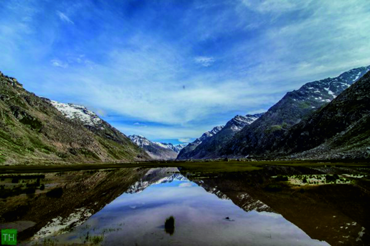
The final section of the Day 5 trek takes you to Mantalai, which is at an elevation of well over 13,000 feet. The path is littered with boulders and murky sections. You'll pass through a series of ridges and swamplands as you travel through the river basin. Mantalai is located directly behind the last ridge, and a mountain crest not far from Mantalai provides spectacular views of Mantalai Lake. A small temple dedicated to Lord Shiva can be found near the river's edge. To get to your campsite, walk to the left of this bank.
Looking for a simple Himachal trek? Beas Kund Trek Manali to explore the details CLICK HERE
Day 6
Day 6 is a day of rest and acclimatisation along the shores of Lake Mantalai. As a result, make sure you rest enough to prepare for the journey ahead. This is especially important because the Day 7 trek will take you to a height of approximately 15,000 feet. With decreasing oxygen levels and more challenging weather, it is critical to avoid altitude sickness. You would have a better understanding of the weather and physical demands of nature if you did a few exercises and took gentle walks here.
Day 7: Mantalai to Parvati Upper Base Camp
The seventh day is a relatively difficult trek of 7 to 8 kilometres. So start the trek early, and at first, it will be level walks as the first half-hour of the trail will introduce you to boulders and moraines. Crossing chilled streams of water would lead you to a mountain base, from which the journey becomes steeper and snow patches begin to appear. It takes about five hours to reach the mountain top, which offers a breathtaking view of the Parvati Valley.
Exotic plants and flowers such as Losar and Brahmakamal can be found along the way. With the climb now literally uphill, it is even more important to tread carefully, as rocks tend to become flimsy at this altitude. You will arrive at your next base camp, which will be named after the Parvati River. It is situated on a plateau at a height of more than 15,000 feet and provides a breathtaking view of the Pyramid Peak, the Parvati South, and the Snow Peak.
HEAVEN ON EARTH THE BHRIGU LAKE TREK HIMACHAL PRADESH
Day 8: Parvati Base camp to Pin Valley Base camp via Pin Parvati Pass
Day 8 is perhaps the highlight of this trek, as it takes you through the Pin Parvati Pass before ending at the Pin Valley base camp. So you'll be nearing the summit of this journey, the eponymous pass, which sits at about 18,000 feet above sea level. This 12 km ascent takes 5-6 hours and features bumpy terrain as well as glacial drifts of rocks and clays.
You'd be trekking to the left of the glacier to reach a plateau with a massive rock in front of you. You'd reach an open snowfield by trudging along the path between the plateau and the rock. It would be a mountain climb from here, and one would have to proceed with caution because snow crevasses could be found lurking beneath the surface. Another two hours of climbing would be required to reach the Pin Parvati Pass. The Pin Valley, Srikhand Mahadev, and Kinner Kailash can all be seen from the pass. Similarly, other peaks such as Bara Shrigiri, Parbati Goat Head Peak, Fluted Peak Kulu Makalu, and others may be visible.
After some rest, you will descend to the Pin Valley base camp via Spiti Valley. The campsite is located at an elevation of slightly less than 15,800 feet.
THE "Queen of Winter Treks." KEDAR KANTHA TREK UTTARAKHAND
Day 9
You'll come across the meeting point of the river Pin and a rivulet a few minutes into the Day 9 trek. You'd be climbing a glacier from there, and you'd come across a nallah as you descended from the glacier. It comes from a river that may be difficult to cross and involves climbing another glacier. It takes about an hour to get to Wichkurung Thatch, a meadow at an elevation of 12,600 feet, from Rampur Bhusarh. This area's entire spectacle includes a cattle grazing field, vibrant flowers, animals, and so on.
Day 10: Tia to Mudh Village
Day 10 entails a descending trail through rugged terrain littered with pebbles and rocks. The sight of free-roaming yaks and bharals grazing on the grasslands would be a sight to behold. Mudh is located about five minutes from Wichkurung Thatch and has a national park with animals such as Tibetan gazelle, Blue Sheep, Ibex, Tibetan Wolf, Snowy Hare, and others. The vibrant mountain peaks here are essentially reflections of wildflowers. Village dwellings can be found in Mudh and Gompa.
'Mountain of the Serpent', The Nag Tibba trek
Day 11: Drive to Manali via Kaza, passing through Spiti Valley.
You could hire a cab to take you to Manali via Kaza. The drive from Kaza to Manali takes about nine hours, and there are many roadside dhabas for some sumptuous meals along the way. This entire journey en route to Spiti Valley is colourful. The arrival in Manali would mark the end of the Pin Parvati Pass Trek, and there are several places to rest and stay here.
Pin Parvati trek difficulty
The Pin Parvati Pass trek is strenuous. One of the reasons it is a difficult trek is that you cover about 100 kilometres and reach very high altitudes (over 17, 000 ft). This trek has a lot of difficult sections. Pushing your body at such a high altitude without acclimatisation can be dangerous.
How to Reach
By Air:-
The nearest airport is in Bhuntar, 52 kilometres from Manali. Taxi services from Bhuntar to Manali are available and cost between Rs. 700 and Rs. 1000. Bhuntar is well-connected by air to Delhi. Indian Airlines, Kingfisher Airlines, MDLR Airlines, and Jagson Airlines operate flights from Delhi and Chandigarh to Kullu.
By Road:-
Manali is easily accessible from Delhi. From Delhi, take an overnight bus to Manali. Tickets can be purchased at www.hrtc.gov.in. Tip: Because the journey from Delhi to Manali is long, most Volvo private buses leave Delhi between 5 and 6 p.m. The last government bus departs from ISBT Kashmere Gate at 8.30 p.m.
From Manali to Delhi Buses from Manali to Delhi leave between 4 and 5 p.m., just like the onward journey. Your estimated arrival time in Delhi will be between 6 and 10 a.m. Plan your subsequent journeys only afternoon, allowing for bus delays.
Note: Trekkers should only take VOVO buses that arrive in Manali before 09.30 a.m. on the first day. Our reporting time is 10.00 am in Manali, but if you are unable to arrive at the meeting/briefing time, we will either transfer your seat to the next batch or cancel your trek, so please double check your bus time with your bus transporter.
Best Time For The Pin Parvati Trek
Monsoon (June to September) pin Parvati trek in September
These are not the typically rainy months in the area, but they are a time when the snow melts and the weather is favourable for the trek, making it the best time to visit the Parvati Pin Pass between June and September. It is possible that heavy rains will be seen in Kullu and Manali during the suggested time frame. Even though it may rain in Kullu and Manali, higher altitudes are always a little warmer and sunnier, with even a little snowfall, which enhances the trekking experience for the entire trekking party. This is the ideal time to go on the Pin Parvati Trek in Himachal Pradesh.
Summers (January to May)
From January to May, the weather is pleasant. However, the snowfall rate is high, making trekking difficult. During these months, however, the temperature ranges from 12°C to 20°C during the day and -6°C to 4°C at night. So doing this activity during the day is preferable.
Winters (October- December)
These months are extremely unfavourable for visiting the area, with extreme temperatures and snowfall making the trek impossible. The temperature drops below zero degrees Fahrenheit, and snowfalls from time to time, making it difficult to navigate through the pass.
Comments
Post a Comment
If you have any doubt please let me know