Valley of Flowers Trek About Valley of Flowers The Valley of Flowers lives up to its name, with an endless supply of flowers in full bloom. The journey could even be renamed a floral fairytale romance! The Valley of Flowers' unique landscape is like a dream come true: an exquisite valley bejewelled with a never-ending stretch of flowers. Between the rocky mountain ranges of Zanskar and the Great Himalayas are lovely meadows studded with indigenous alpine flora. The area, which is a UNESCO World Heritage site, was designated as a national park in 1982. The endless stretch of gorgeous vegetation, dotted with colourful blossoms of pink, yellow, purple, red, blue, and orange hues, is the highlight of this excursion. Throughout the hike, the fragrant scent of the carpeting flowers entices you. Botanists, flower lovers, bird watchers, wildlife photographers, hikers, environment enthusiasts, and adventure seekers from all over the world are drawn to the valley's unspoiled beauty. It...
The Most Beautiful Treks of Uttarakhand

Uttarakhand is known as the "Land of the Gods." The Indian state of Himachal Pradesh, located west of Nepal, is considered the Himalayan epicentre. All travellers looking for hikes know Uttarakhand as the first word that springs to mind. The trekking trails in Garhwal and Kumaon (Uttarakhand) are divided into three categories: easy, moderate, and difficult.
The state is home to the majestic Gangotri Glacier, the Ganges River's source. It is a holy region and a popular pilgrimage destination for Hindus. The state is also home to India's second tallest peak, the Nanda Devi, which rises to a height of 25,643 feet. Needless to say, there are numerous hiking trails in the area Uttarakhand.
Uttarakhand treks are capable of entertaining both amateur and professional trekkers. People come from all over the world to trek and explore Uttarakhand's hidden gems, as well as to walk on the less travelled pathways. Treks like Kedarkantha and ChoptaTungnath have become increasingly popular in recent years.
Trekking in the Kedartal

While Uttarakhand has several treks that provide an unforgettable experience, the Kedar Tal Trek is all about being transported to a mythical realm. Kedar Tal is a challenging walk that can be used as a warm-up for other difficult high-altitude treks in India.
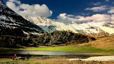
Kedartal, popularly known as "Shiva's Lake," is one of Uttarakhand's tallest lakes. The Uttarkashi district's pristine glacial lake is located at an elevation of 4,912 metres above sea level. The melting of the Kedar glacier creates Kedar Tal Lake, which gives birth to the Kedar Ganga River, an important tributary of the Bhagirathi River.
This Uttarakhand trip, located in the Gangotri district of the Garhwal Himalayas, is perfect for mountaineers because it gives spectacular views of the Great Himalayan ranges, including the Jogin peaks, the Bhirgupanth peak, and the Thalayasagar peak.
Uttarakhand's hidden jewel is this high-altitude glacier lake. On the Kedartal Trek, travellers can see numerous mountain wildlife species such as the Blue Sheep, Goral, and the iconic Himalayan Black Bear among the snow-covered peaks and terrain.
The breathtaking vistas of this alpine lake, as well as the tall and enchanting mountains of Thalaysagar, Bhrigupanth, MandaParvat, Jogin, and Gangotri, are the reward for this walk. The KedarKharak camping location, which is located in a meadow with a wide stream running through it, adds to the trek's uniqueness. Sunsets from the campsite are spectacular.
Maximum Altitude:16,110 feet
Trek Duration:7 days
Best Season: During the months of May-June and September-October
Difficulty Level: Moderate
Kedarkantha Trek

During the winter, the Kedarkantha trip is blanketed in shimmering snow, providing a spectacular vista of the Himalayan peaks. It's in Uttarakhand's Sankri range. Kedarkantha
The prospect of traversing nearly 18 kilometres in just 4-5 days while climbing to a height of over 6000 feet may sound daunting, but the breathtaking 360-degree vistas of many famous mountain peaks in Kedarkantha make it worthwhile. Beginning in the Uttarakhand town of Sankri, you will feel as if you had touched the sky by the time you reach the Kedarkantha mountain.
Kedarkantha Trek, one of Uttarakhand's most popular winter treks, is a trekker's delight and a rookie's rite of passage due to its relative easiness. This walk, which is covered in shimmering snow throughout the winter, provides a beautiful perspective of the mighty Himalayan peaks. It also provides trekkers with a once-in-a-lifetime opportunity to see life in the most distant of settlements in the dead of winter! The Kedarkantha walk offers unrivalled beauty, with breathtaking vistas of picturesque villages, meadows, snow trails, and a dramatic scenery filled with lovely lakes, mountains, quiet rivers, and enormous Himalayan peaks.
The Kedarkantha walk also offers a wonderful opportunity to take in the scenery and experience the li
Maximum Altitude: 12,500 feet
Trek Duration: 5 days
Best Season: December-April
Difficulty Level: Easy
Har Ki Dun Trek

This is one of the most accessible treks in the Himalayan region of Garhwal. Explorers will be able to see the picturesque Tons River valley, which is surrounded by highlands and deep trees, during the Har Ki Dun journey. The pre-monsoon spring months are good for bird watchers, while the post-monsoon season is ideal for flora enthusiasts, as these months see the most blooming. In the months of December and April, there is plenty of snow on the trail, making it ideal for snowshoers. This walk is sublime, as it is steeped in mythology.

Harki Dun is a cradle-shaped valley in the centre of GovindBallabh Pant National Park, at a height of 3566 metres. Har-ki-Dun, surrounded by snow-capped peaks and alpine vegetation, is without a doubt one of the most stunning hiking destinations in Uttarakhand, showcasing the state's unparalleled natural beauty. Harki Dun Valley provides breathtaking vistas of unspoiled valleys in the Garhwal Himalayas. It is one of India's most picturesque destinations, with several trekking opportunities.
Maximum Altitude: 11500 feet
Trek Duration: 7 days
Best Season: March to June and September to December
Difficulty Level: Easy
Valley of Flowers Trek.

The journey to Valley of Flowers, a UNESCO World Heritage Site, is one of Uttarakhand's easiest, and trekkers can attempt it without the assistance of local trekking firms. The spectacular display of wildflowers attracts travellers to this 4-5 day walk. Trekkers should expect a lot of rain and plan accordingly. Trekking up to Hemkund Sahib, a pilgrimage site sitting at 14,200 feet, is also an option. Rest certain that the beauty of the wildflowers will compensate for any hardships!
The Valley of Flowers is a bouquet of nature softly cuddled in the West Himalayan area of Uttarakhand, bestowed with rare and exotic Himalayan flora. The Valley of Flowers journey follows the Pushpawatiriver, passing through lush forests and traversing numerous bridges, glaciers, and waterfalls along the way.
This stunning natural wonder is both an Indian National Park and a UNESCO World Heritage Site, with lush meadows blooming with rare alpine flowers and rich wildlife.
Brahmatal Trek

Brahmatal, a lake nestled in the depths of Uttarakhand's Himalayas, is steeped in legend. Brahmatal is one of the few Himalayan sites open for trekking in December, January, February, and March when winter sweeps across the slopes.
Changing vistas, from deep and shady forests of oaks and rhododendrons to snow-covered meadows, lakeside camping at Bekaltal, the alpine Brahmatal lake region, and a climax vision of fantastic high peaks gleaming across a dazzling sky are all pull factors on this walk. Because massive ice-capped summits like Mt. Nanda Ghunti and Mt. Trishul are rarely visible from a low-lying hike like this one, the Garhwal snowline panorama is all the more stunning.
The Brahmatal Trek route is suitable for novices and less experienced hikers because to its gradually ascending undulating slopes. The walk spends most of its time in the woods, which reduces the risk of altitude sickness. The sweet mellow of falling snow, a fascinating trail trapped in an absolute whiteout, the depthless calm inside the grove of rhododendrons and oaks, and iced over lake water faces will not deprive one of an out and out spectacular winter experience.
Photographers will like this trek's numerous frames, which include snow-covered forests, white-gold high peaks in alpenglow, and a barren alpine mountain-scape of a lone tree standing on the frozen banks of the Brahmatal lake.
Altitude: 12,500 feet
Trek Duration: 10-14 days
Best Season: December to February
Difficulty Level: Easy
NANDA DEVI BASE CAMP TREK
Although Nanda Devi is regarded as one of the most magnificent mountains in the world, its base camp must be included among Uttarakhand's finest hikes. Because the Nanda Devi Inner Sanctuary, which would otherwise have provided the closest encounter with India's second-highest mountain, is restricted to visitors, this journey, which begins in the state's Upper Kumaon Region, allows one to reach the closest to the twin peaks of Nanda Devi Mountain.
Nanda Devi East Base Camp is a challenging trip that should only be attempted by experienced trekkers who are willing to put in 14 days of hard work in exchange for magnificent views of a less-travelled and bizarre region in Uttarakhand. Gori Ganga River is a regular companion on our expedition. The trek's starting ascent is rather straightforward, but the obstacles steadily grow as one ascends in altitude. Trekkers will get the opportunity to see bizarre rural settlements, lush meadows, and beautiful waterfalls every few kilometres along the way.
This walk will include a lot of switchbacks between oak and deodar woodlands, as well as narrow ridges. In Martoli, one can also pay tribute at the Nanda Devi Temple, which is located in the shadow of this huge peak. The walk also passes through birch and rhododendron forests, which will likely melt your heart with their breathtaking sights. The trek's last stretch requires crossing multiple ice bridges and rocks, but the view of the spectacular Nanda Devi afterwards more than compensates for the difficulties.
Altitude: 1850m to 4800m
Trek Duration: 17 Days (4 days travelling/14 days trekking)
Trek Gradient: Difficult
Roopkund Trek
Roopkund Trek is one of the most popular trekking routes in Uttarakhand. Roopkund Lake tucked away in a pristine and less-visited part of Uttarakhand, is a place where adventure enthusiasts should plan a trek.
When one has the opportunity to travel through the picturesque Ali and Bedni meadows, as well as the gurgling and scintillating streams, only to arrive at a pristine lake fringed by 300 human skeletons, it's hard not to feel eerie. Apart from its remote location and strenuous but beautiful hiking trail, Roopkund is well-known for its mysterious human skeletons, which are said to have been present for centuries.
Returning to the trek, Roopkund offers a challenging trail with rewarding views. Throughout the trek, you can see the Chaukhamba range, Neelkanth Peak, Kedarnath, Kedar Dome, and several other mountains, as well as the imposing Himalayan Mountains Trishul (7120 m) and Nanda Ghunti (6309 m). The trail is riddled with steep climbs and slick descents, but the end result is always memorable.
Altitude: 2438m to 4876m
Trek Duration: 08 Days (5 days trekking and 3 days travelling)
Difficulty level: Moderate
Kuari Pass Trek
Kuari Pass trek in Uttarakhand is considered one of the best treks for beginners. It begins with an ancient forest trail, then opens to a meadow, and then cuts and runs through oak and rhododendron forest. The trekking route begins in Guling and passes through places with breathtaking views of the Himalayan peaks.
Mt Nanda Devi (7816m), Mt Dronagiri (7066m), Hathi Peak (6727m), and Ghoda Peak can all be seen along the way. A 360-degree view of Himalayan Peaks like Chaukhamba, Neelkanth, and Nilgiri awaits one upon reaching the ridge (on Lord Curzon's Trail) after climbing up from Khullara.
Aside from the breathtaking views, this trekking expedition also includes a fantastic camping experience for the trekkers. There aren't many treks with such beautiful camping spots, but Kuari Pass is one of them. Camping can be enjoyed in places like Chitrakantha and Khullara, with Mt Dronagiri as a backdrop. Kuari Pass is a fantastic Uttarakhand trek.
Altitude: 2040m to 3814m
Trek Duration: 9 Days (6 days trekking and 3 days travelling
Difficulty level: Easy to Moderate
Mt Shivling Trek
The Mt Shivling Trek is very similar to the Gaumukh-Tapovan trek. Throughout the trek, one can expect to be awestruck by nature's surreal beauty. This trip to Uttarakhand gives you the chance to see one of the most beautiful mountains in the Indian Himalayas from top to bottom.
The trekking route for Mt Shivling begins in Gangotri and runs along the Bhagirathi River, passing through pine forests on occasion. During this trek, one can also travel through the lovely Tapovan meadow, which stretches far and wide and serves as the best campsite.
The distant views of the Bhagirathi Peaks and the glacier are a sight to behold. The Gangotri Glacier Walk, which is both beautiful and thrilling, is the highlight of this trek. The surreal views of Mt Satopanth (7075m) and Vasuki Tal (4880m) are also likely to leave an indelible impression on your mind.
Altitude: 3048m to 4800m
Trek Duration: 13 Days (including travelling and trekking)
Difficulty level: Easy to Moderate
Kalindi Khal Trek*
Kalindikhal is a difficult trek in Uttarakhand that takes you through half of the Garhwal region. The Kalindikhal Trek begins in Gangotri and ends in Badrinath, Uttarakhand's most famous religious destination. However, walking over glaciers, boulders, scree, and snowfields is a difficult trek that requires a lot of physical stamina and skill.
The imposing views of majestic Himalayan Mountains such as Mt Satopanth (7075m), Vasuki, Bhagirathi, Shivling (6543m), and Chandra Parvat are guaranteed on this adventurous journey through Bhagirathi River Valley to Alaknanda River Valley. The trek also provides views of majestic and dreamlike alpine lakes such as Vasuki Tal (4880m). Even though it is only for experienced trekkers and can only be completed after several difficult days of trekking, it is a rewarding expedition in the Uttarakhand Himalayas.
Altitude: 3048m to 5946m
Trek Duration: 10 Days
Difficulty level: Difficult
Garuda Peak Climbing Trek

Garuda, one of Uttarakhand's lesser-known peaks, stands at 6000 metres and makes for interesting trekking and climbing expedition. The unsurpassed beauty of the Garhwal Himalayas, which includes charming remote villages, mighty mountains, and glaciers, is on display during the Garuda Peak Climbing Trek.
The journey to Garuda Peak begins in Jumma, about 45 kilometres from Uttarakhand's most popular tourist destination, Joshimath. The trekking trail then passes through the villages of Ruing and Dronagiri, where you can interact with the locals and get a glimpse into their daily lives. Hathi Parbat (6507m), Gauri Parbat (6708m), Staminal (6911m), Dunagiri Parbat (7066m), Trishul Parbat (7120m), Mt. Kalanka (6931m), Changabang Parbat, and several other peaks can be seen during the 8-day trek.
Altitude: 2286m to 6000m
Trek Duration: 11 Days (including travelling and trekking)
Difficulty level: Moderate to Difficult
Milam Glacier Trek
Milam Glacier, one of Uttarakhand's most popular treks, had to make this list because of its breathtaking trail and excellent trekking experience. This expedition is probably one of the best ways to see the upper reaches of Uttarakhand's Kumaon region, which includes seeing some surreal valleys and meadows, finding the Goriganga's source, and visiting Martoli's high-altitude Nanda Devi Temple.
The hike also provides views of some breathtaking gorges with glistening streams. The sight of abandoned villages, as well as the lofty mountain peaks of Nanda Devi and Trishul, make this trek worthwhile. Milam Glacier trek begins in the charming town of Munsiyari, which is known for offering breathtaking views of the Panchachuli Peaks. Milam Glacier trek is truly an epitome of adventure, and it serves as an inspiration to keep the flame of exploration burning brightly.
Altitude: 2290m to 4200m
Trek Duration: 13 days (4 day traveling/9 days trekking)
Difficulty level: Moderate
Adi Kailash & Om Parvat Trek

A journey to see two stunning and sacred mountains in the Uttarakhand Himalayas is a once-in-a-lifetime experience. Adi Kailash (5945m), also known as Little Kailash, and Om Parvat (6191m), which is distinguished by a prominent OM sign naturally marked by the snow, make for an interesting trek in the Kumaon Himalayas. A 12-day trek starting from Dharchula in Pithoragarh District can cover the two mountains that appear to be very close to each other.
The scenic hiking trail passes through lush valleys, charming little tribal villages, and picturesque farmlands. The expedition also gives you the chance to see the sacred Gaurikund (High Altitude Lake) at the foot of Adi Kailash Mountain, where you can pray. Trekkers can also see the majestic Annapurna Peak in Nepal from a distance on a clear day. The Adi Kailash & Om Parvat Trek is truly magical, and nothing compares to its natural beauty or aura.
Altitude: 950m to 4419m
Trek Duration: 12 Days (including travelling and trekking)
Difficulty level: Difficult
Dayara Bugyal Trek

Do you want to feel as if you're walking right into the Windows wallpaper? Then you must travel through Dayara Bugyal, a high-altitude meadow that grazes Uttarakhand. Dayara is considered one of India's top two alpine meadows destinations, the other being Bedni Bugyal, which is also in Uttarakhand. Dayara Bugyal is a beginner-friendly all-season trek that can be reached from Raithal, which is a 9-hour drive from Haridwar's famous tourist attraction.
If you plan your Dayara Bugyal Trek for the beginning of spring, you'll be treated to a visual feast of multi-hued flowers strewn throughout the meadow. Its easy to moderate trekking trail cuts and runs through oak and rhododendron forests, which are absolutely stunning, with a breathtaking backdrop of lofty Himalayan peaks such as Bhagirathi Peaks, Bandarpoonch, Black Peak, and several other snow-capped mountains. Dayara is a photographer's dream, and a must-see for any new trekker eager to discover Uttarakhand's natural beauty.
Altitude: 2255m to 3810m
Trek Duration: 06 Days (3 days travel/3 days trek)
Difficulty level nt: Easy to Moderate
Rupin Pass Trek

Rupin Pass, a moderate to difficult grade trek in Uttarakhand, is one of the most amazing crossover treks to do in the months of May and June. The trekking trail is challenging, as expected, but the views are worth it, and the experience, well, it's unrivalled. The trek is full of surprises, with new and stunning vistas every few kilometres, making it a classic adventure experience in Uttarakhand that no seasoned trekker should miss.
Rupin Pass is reached via a trail that begins in Dhaula, Uttarkashi District, and passes through glacial meadows, glacial valleys, snowfields, snow bridges, and numerous waterfalls. The steep ascent for crossing Rupin Pass is the main highlight of the Rupin Pass trek. Another highlight of this Uttarakhand trek is the Lower Waterfall Campsite, where you can camp in lush meadows surrounded on three sides by towering Himalayan peaks.
Altitude: 4657m
Trek Duration: 14 days (3 days travel/9 days trek)
Difficulty level: Moderate-Difficult
Bagini Glacier Trek

Bagini Glacier is a great summer trek in Uttarakhand, and it's best done between early May and mid-June. If we had to be honest, we'd say Bagini feels a lot like climbing to the coveted Everest Base Camp, only much quieter. No, we aren't making things up. Bagini Glacier trek begins in Jumma, about an hour's drive from Joshimath, and takes you through one of the best stretches of the Garhwal Himalayas.
You'll pass through Ruing, a remote village, and Dronagiri, an alpine hamlet, and get a closer look at mountain peaks like Changbang and Kalanka. The trekking trail is mostly difficult, with steep hikes beginning in Ruing Village and leading into a barren and non-vegetative mountain region. This trek is a must-do in Uttarakhand's summers because of the breathtaking views of alpine meadows, ancient houses in Dronagiri Village, lofty snow-capped peaks, and Bagini Glacier.
Altitude: 4483m
Trek Duration: 10 Days (4 days to travel/6 days to trek)
Difficulty level: Moderate-Difficult
Mt. Meru Base Camp Trek
This is your chance to learn about Mt.Meru Base Camp if you haven't already. Meru is a 6660m tall peak in the Garhwal Himalayas that is considered one of Uttarakhand's best treks. The trekking trail from Gangotri to Tapovan is the same as the Gaumukh-Tapovan Trek, and from Tapovan, a trail through glacial landscape leads to Meru Base Camp.
The views are breathtaking throughout the trek, with lofty Himalayan peaks and the Bhagirathi River as constant companions. On this trek, one can see Mt Shivling and Mt Thalaysagar, two beautiful peaks.
Altitude: 5263m
Trek Duration: 10 Days (4 days travel/6 days trek)
Difficulty level: Moderate – Difficult
Panch Kedar Trek
Panch Kedar is unquestionably one of Uttarakhand's most popular treks. It is a religious trek that also tests your physical strength and stamina at times. In fact, this trek in Garhwal combines spirituality and adventure, with the opportunity to visit five important Shiv Temples – Kedarnath (3584m), Madhya Maheshwar (3289m), Tungnath (3810m), Rudranath (2286m), and Kalpeshwar (2134m) – as well as trudging some of Uttarakhand's toughest trails.
The Panch Kedar trek begins in Helang, just before Joshimath, with a visit to the first temple, Kalpeshwar. This 15-day trek concludes with darshan at Kedarnath, which is situated in one of the most bizarre settings one could imagine. The advantage of doing this trek in the summer is that you can take in the beauty of the lush meadows and rhododendrons in full bloom. The trekking trail to Madhmaheshwar is the most difficult of the five temples, but it is also the most rewarding.
Altitude: 3682m
Trek Duration: 15 Days
Difficulty level: Moderate – Difficult
Bali Pass Trek
Bali Pass, which connects Yamunotri and Har ki Dun valley, is a thrilling Uttarakhand trekking experience. Although the trek to Bali Pass is difficult, it rewards hikers with spectacular views of ancient villages, alpine meadows, Ruinsara Lake and River, and, of course, the high altitude pass.
Passes through the Supin Valley, where the Supin River can be seen flowing. Before reaching Gangad Village, the trail ascends a small incline. The confluence of the Har Ki Dun and Ruinsara rivers is the highlight of Bali Pass, aside from the adventure of crossing it. The Ruinsara Lake, nestled among the meadows and set against the backdrop of Swargarohini Peak, is another highlight of this trek.
Altitude: 4939m
Trek Duration: 8 Days (3 days travel/5 days trek)
Difficulty level: Difficult
Panwali Kantha Trek

Panwali Kantha is a lesser-known but easy summer trek in Uttarakhand. The hike passes through some of the state's most beautiful alpine meadows, as well as scenic landscape and a variety of flowering plants and trees, including red and pink rhododendrons.
This trek in the Garhwal Himalayas is one of the few where you can see the entire range of mountain peaks of Yamunotri, Gangotri, Kedarnath, and Badrinath. Thalaysagar, Meru, Kirti Stambh, Kedar Dome, Kedarnath, Chaukhambha, and Nilkanth are some of the major peaks visible on the Panwali Kantha trek. This trek begins in Sonprayag and continues to the remote side of the Garhwal region, passing through the sacred temple of Triyuginarayan.
Altitude: 3300m
Trek Duration: 9 Days (4 days travel/5 days trek)
Difficulty level: Easy
All The above Treks are the most beautiful treks in Uttarakhand. To know more about places to visit in Uttarakhand CLICK HERE
Comments
Post a Comment
If you have any doubt please let me know