Valley of Flowers Trek About Valley of Flowers The Valley of Flowers lives up to its name, with an endless supply of flowers in full bloom. The journey could even be renamed a floral fairytale romance! The Valley of Flowers' unique landscape is like a dream come true: an exquisite valley bejewelled with a never-ending stretch of flowers. Between the rocky mountain ranges of Zanskar and the Great Himalayas are lovely meadows studded with indigenous alpine flora. The area, which is a UNESCO World Heritage site, was designated as a national park in 1982. The endless stretch of gorgeous vegetation, dotted with colourful blossoms of pink, yellow, purple, red, blue, and orange hues, is the highlight of this excursion. Throughout the hike, the fragrant scent of the carpeting flowers entices you. Botanists, flower lovers, bird watchers, wildlife photographers, hikers, environment enthusiasts, and adventure seekers from all over the world are drawn to the valley's unspoiled beauty. It...
Kedarkantha Trek Uttarakhand

Kedarkantha is such a well-known winter trip that it's been dubbed the "Queen of Winter Treks." It is famous among hikers because of the knee-deep snow in the winter, the stunning view from the top, and the gorgeous and simple pathways. The Govind National Park's lush pine trees are home to the 'easy on endurance' path. The vistas from the top are well worth the ascent to 12,500 feet.
The Kedarkantha trip will provide you with an unforgettable view of the cosmos, lush meadows, snow trails, picturesque villages, scented pine forest, sky-scraping peaks, serene rivers, and mythological storey whispers.
To know about the Hampta Pass Trek Click Here
The Kedarkantha Peak, adorned with the exquisite beauty of falling snow and bordered by pine trees, is one of India's most popular snow trekking sites. It's a mesmerising pictorial image with falling winter snow, and what's more beautiful is the view of the mighty Himalayas from the pathways all the way to the top. This perfect trekking track, which spans a total distance of 20 kilometres, is located at a height of 3810 metres (12,500 feet). The distance is short, and the hiking track is not very tough, allowing even first-time trekkers to embark on an adventure and enjoy nature at its best.

This walk has all the lovely marvels that a trekker wishes to encounter and witness in his journey, from the beautiful and captivating vistas of the snow-capped Himalayas, verdant foliage, rich landscapes, a vast collection of flora, frozen ponds, to the sights of hypnotic peaks. The Kedarkantha Trek is an ideal destination for nature lovers to bask in the beauty of undisturbed nature and enjoy delightful and blissful moments with exhilarating experiences. Not only for adventure seekers and trekkers to enjoy thrilling challenges, but the Kedarkantha Trek is also an ideal destination for nature lovers to bask in the beauty of undisturbed nature and enjoy delightful and blissful moments with exhilarating experiences.
The Kedarkantha Trek, located in Western Garhwal's Uttarakashi region, is recognised for being one of the country's easiest treks, suitable for both experienced trekkers and those with no prior trekking experience. However, physical fitness is necessary, with participants needing to be able to jog for at least 4 kilometres in 30 minutes before signing up for the walk. As the altitude climbs, the air becomes thinner, and individuals must also wear backpacks, which might be challenging if they are not physically fit.
Uttarakhand trekking is always a pleasure because of its breathtaking beauty and panoramic natural vistas that are unrivalled by any other place in the country. However, among all the fascinating destinations and exciting trekking sites available, the snow treks of Kedarkantha inspire every trekker greatly. In reality, there are numerous reasons why it is such a fantastic walk that it is so popular with enthusiastic tourists.

The first reason is that snow is available until the end of April, making it one of the top winter trekking destinations in the world. What's more, at a height of only 10,000 feet, one can see the beautiful snows at the base of the pine trees. The magnificent campgrounds, where each site is unique in its own way and does not compare in beauty to any other campsites along the road, are the second reason for its appeal. Another feature of this hiking trail is that it begins in a deep pine forest, where one can begin the trip by walking over a bed of brown dried leaves, providing a one-of-a-kind experience and a breathtaking perspective.
CLICK HERE to know about the Bamboo Trail Trek
Last but not least, there's the magnificent jaw-dropping, breath-taking vista of the famed snow-capped mountain summits that greets visitors as soon as they enter Kedarkantha base, and the view grows more breathtaking with each step closer to the summit. Overall, the trekking tour guarantees a rejuvenating and heart-warming experience, which is why the destination attracts millions of people every year.

Though the Kedarkantha journey may be done virtually all year, the awe-inspiring views available during the winter months of December to April cannot be compared to those available during the summer. The snow-covered hiking routes and buckets of snow at the base of the pine trees are a captivating sight to see that can only be experienced during the winter months. In reality, the winter months are a time of celebration for the residents, who take part in a variety of festivities during this period. However, it is best to avoid these trails during the monsoon season.
About the trek
Dehradun is the starting point for the journey to the picturesque Kedarkantha summit. It takes roughly 10 hours to drive from Dehradun to Sankri, which is located at an altitude of 6400 feet. It is 220 kilometres from Dehradun. The hike begins the next day from Sankri and takes around 5 hours to reach JaduKaTalab, which is located at an elevation of 9100 feet. This walk takes you through lush meadows, deep pine forests, cascading stunning streams, and magnificent maple trees. The hikers are required to remain in tents at the first campground. The following day, one must hike up to 11,250 feet to reach the Kedarkantha base, a distance of around 4.5 kilometres from Jadukatalab.

Trekkers on this trail pass through lush meadows and, for the first time, see many snow-capped peaks encircling the area for the first time. The Kedarkantha peak, at a height of 12,500 feet, is the next stop, and this trail can be a little more difficult than the others. However, the stunning vistas of the intriguing Himalayas make up for all of the hard work. After summiting the mountain, the route back begins with a stop at Horegaon camp at an elevation of 8900 feet, which can be reached the same day evening. The next day, a trail through dense pine forests leads back to Sankri. It's a long journey back to Dehradun and then forward from Sankri.
CLICK HERE to know about the Satopanth Glacier Trek
The Kedarkantha Trek is one of the most exciting and thrilling trekking excursions available, offering all the thrills but with fewer hurdles and in a shorter amount of time. It's a week-long tour that can be easily commuted through Dehradun, which is conveniently accessible from anywhere in the country. The journey is one of the most affordable trekking tours available, and it can be enjoyed in complete luxury.
Kedarkantha Trek – All You Need to Know
Kedarkantha Trek at a Glance
Moderate difficulty (Suitable for Beginners) Dense Pine and Oak forests, broad meadows, and snow in the winter on the Kedarkantha Trail. Uttarakhand is a state in India. Sankri is the starting point (200 km from Dehradun) Kedarkantha Peak is at a height of 12,500 feet, ranging from 6,000 feet at Sankri to 12,500 feet at Kedarkantha Peak. The Kedarkantha Trek is a 25-kilometre journey (Approx) Duration of the Kedarkantha Trek: 4 days (Sankri - Sankri) December to April is the best time to go on the Kedarkantha Trek.
The Kedarkantha walk begins in Uttarakhand's picturesque village of Sankri, which is at an elevation of 6,000 feet. The Kedarkantha trip, which passes through dense pine and oak tree woods, frozen lakes, and snowy trails on its way to the 12,500-foot Kedakantha summit, offers panoramic vistas of snow-capped peaks practically the entire way. The walk takes about 4 days from Sankri to Dehradun and back, plus additional days for travel from Dehradun and beyond.

Brief information of the trek
Day 1: Arrival at Sankri : Altitude: 6,400 feet, 220 km drive - approx 10 hours
Day 2: Sankri to Juda-ka-Talab : Altitude: 6,400 feet to 9,100 feet, 4 km trek, approx 5 hours The trail passes through dense pine forests, maple trees, few streams and finally opens out to beautiful meadows. Stay in tents
Day 3: Juda-ka-Talab to Kedarkantha Base : Altitude: 9,100 feet to 11,250 feet, 4 km trek, approx 2.5 hours. Most of today’s trail is on a ridge, under oak trees. You will also pass through some meadows where you can spot shepherd log huts Peaks:-Bandarpoonch, Swargarohini, Kala Nag and Ranglana stand among the others. Stay in tents
Day 4: Kedarkantha base to Kedarkantha peak; descend to Hargaon camp : Altitude: 11,250 feet to 12,500 feet to 8,900 feet, 6 km trek, approx 7 hours. Spend some time at the summit and descend back to the base camp by noon for lunch. Post lunch, descend down to Hargaon. Reach Hargaon by evening. Stay in tents
Day 5: Hargaon camp to Sankri : Altitude: 8,900 feet to 6,400 feet, 6 km trek, approx 4 hours. Descend 2500 feet through dense pine forests
Day 6: Departure day (Sankri to Dehradun) : Distance: 220 km drive, approx 10 hours.
Who Can Go :
You can apply if you are a first-timer and have an interest in trekking and mountaineering. The climber must be physically fit and have the energy to cover 5 kilometres in 45 minutes without tiring. The climber should be able to carry a rucksack weighing 10 kg. This mission will not be able to resolve heart problems, excessive blood pressure, asthma, or epilepsy. The climber must not be suffering from any of the aforementioned ailments.

Detailed information of the trek
Day 01: Arrival at Sankri
Dehradun is the starting point for the unusual and interesting Kedarkantha Trek. The trekkers should arrive in Dehradun the day before the trip starts. On the National Highway 123, Sankri is located at a distance of 220 kilometres. It's a long beautiful drive in a comparable vehicle that provides complete comfort to trekkers so they can enjoy the scenery.
The gorgeous surroundings add to the delight of arriving at the location and excite the excitement of the exhilarating excursion yet to be experienced. The travel is long, and it will take you till the evening to get to your destination. In the middle, one can take a lunch break at one of the popular eateries and sample some local cuisine with homemade spices. The final 22 kilometres to Sankri are even more fascinating since they pass through Govind National Park, which is known for its extensive variety of flora unique to this region and not found anywhere else in the country. The planned arrival time in Sankri is 5 p.m., although due to some uneven and bad roads in some regions, this may take longer. a little bit more
The Triund Trek Dharamsahal to know more about the trek click here
However, once you arrive at your location, you can check into the hotel you reserved in advance. After freshening up, one can spend the evening relaxing indoors or exploring the lovely Sankri village, which has a collection of local stores and a small market offering largely daily necessities, as well as a few dhabas. Because the BSNL network is so unpredictable in this area, obtaining phone lines can be challenging. The breathtaking grandeur of the setting sun on the Greater Himalayas from Sankri, on the other hand, is a spectacular sight to behold. Dinner can be eaten on the hotel premises or at one of the dhabas nearby.
Day 2: Sankri to Juda-ka-Talab
Although the vacation begins in Dehradun, the trekking excursion begins only in Sankri. After an early start and a substantial breakfast at the hotel, it's a straight shot to JudaKaTalab, which sits at an elevation of 9100 feet. It's a 4-kilometre trip that will take you about 5 hours to complete. The excursion begins with a trip out of the Sankri hamlet via the Sor extension. After passing through the settlement, the route takes a sudden right turn and climbs steeply. This is the road that leads to the Kedarkantha as it follows the stream. The first part of the ascent would involve crossing multiple bridges amid dense forest trees and a thick blanket of brown maple and pine leaves.
Everyone is amazed by its wonderful vision and graphic image. The trail is wide, and you may hear running streams all the way along, but they may not be visible until much farther on. On the road, one can see isolated communities where women and children are carrying bundles of wooden logs, wooden sticks, and dry leaves for domestic cooking and night fires. On the way up, you may see Himalayan Languages swinging from one tree branch to another while crunching the dried maple and oak leaves. Though they are shy animals, it is difficult to get a good glimpse of them since they move fast out of the range of vision.
Apart from that, you can see boars, martens, and hares in this area. The scene changes dramatically in the summer when the lush meadows remain verdant green and hilly flowers of many kinds bloom. After crossing a few streams and continuing on the trail, one can reach the lovely pictorial place of JaduKaTalab, which is not to be missed by any trekker due to its stark contrast and distinct beauty.

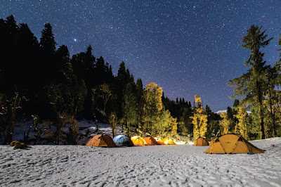
JaduKatalab is a destination that is far too ideal. The stark contrast between a massive lake on the left and dense pine and oak forest on the right creates an enthralling setting in Mother Nature's lap and an ideal campsite for a great evening. To get the most out of the location, one might do things like photography or go on a nature walk. Under the clear sky, a nighttime bonfire can also be a fantastic option for sharing a light supper and warm drinks. The night sky, on the other hand, is a visual feast, with dazzling and shining stars creating a lovely ambience that all hikers enjoy. Tents are used for overnight sleeping.
Day 3: Juda-ka-Talab to Kedarkantha Base
The enthralling journey continues the next day, with trekkers destined to walk to Kedarkantha base, which is located at an elevation of 11,250 feet. The distance from JaduKaTalab to this location is around 4 kilometres, and it takes about 2.5 hours to drive there at a moderate speed. Set out on the next journey after breakfast, where the trail is relatively straightforward and well-visible. The trail begins by passing through deep pine and oak forests, as well as steep ridges and considerably more dense sections. Many shepherd houses in open meadows may be seen along this trail, which is as delightful to behold.

Only during the winter months can one see signs of snow in and around the track at an altitude of roughly 10,400 feet. The track continues to Kedarkantha Base, travelling through dry oak woodlands, extended meadows, and through alleys around shepherd houses. During this time, one can take a long pause to re-energize the body and enjoy the mesmerising view of natural splendour in the area. area. Just before arriving at the Kedarkantha Base, one may take in the breathtaking views of the arc-shaped range of snow-capped mountains, including Bandarpoonch, Swargarohini, Kala Nag, and Ranglana, which stand proudly displaying their magnificence. After arriving at the base, pitch the tent in a suitable location that is open and provides a clear view of the night sky.
However, it is preferable to be in a small group rather than dispersed in the dark. The twilight sky is just as lovely, with bright stars and planets adorning the sun. The Milky Way stretching from one end to the other, the thick network of stars, and the gleaming summit of the mountain all come together to offer an awe-inspiring view that remains engraved in the mind as the night progresses. However, because to the possibility of cold waves at such a height, suitable woollens should be taken for protection. Sleeping in the tent for the night.

Day 4: Kedarkantha base to Kedarkantha peak; descend to Hargaon camp
The trek's fourth day is dedicated to summiting the Kedarnath Peak. Today's journey will take the trekkers from 11,250 to 12,500 feet in elevation. The day's itinerary involves trekking to Kedarkantha peak and then descending to Hargaon camp, which is located at an elevation of 8900 feet. The route is 6 kilometres long and takes roughly 7 hours to complete at a moderate speed. It is ideally a long day, but the thrill of the journey and conquering the peak would be significantly larger and far more worthwhile than the problems that the visitors will face.
You can start the day early with a hearty breakfast and a breathtaking sunrise over the Kedarkantha meadows, which is pure and divine. The first rays of the early light can be used to collect as much energy as possible for the day ahead. The gorgeous peak may even be seen from these meadows, adding to the excitement. There are various trails that lead to the top, but the main trail is preferred because it continues to rise steadily. Trekkers will pass through a few sections of oak forest on this route, but the journey will be much easier and faster.

Climbing through the forest to the end will get you considerably closer to the Kedarkantha summit. The walk becomes a little more tough and arduous near the finish of the trail and close to the top, especially for first-time hikers. The view from the summit and the magnificent setting, though, is well worth the effort. A lovely but modest temple dedicated to Lord Shiva and goddess Parvati may be seen at the summit of the peak. There is also a modest shrine dedicated to Lord Ganesh.
The breathtaking 360-degree vista of Uttarakhand's snow-capped hills is intoxicating and beyond words. Relax for a while at the summit, taking in the beautiful splendour of nature, before descending to base camp about lunchtime. Take a pause after arriving at the camp for lunch and refreshments. Set out to descend farther to Hargaon camp once you've relaxed. It's time to return to the vast oak forests, pine and maple trees, shepherd huts, and icy streams of the past. Descend further to Horegaon campground, savouring the grandeur of the region and taking use of the regular clearings, which are peculiar to the Kedarkantha journey. When you arrive at the campsite, pitch your tent and mark the end of the trail Another enjoyable day, complete with dinner and an overnight stay in the tent. However, enthusiasts travellers can build a campfire here and enjoy the nighttime environment while speaking and having a wonderful time with their journey companions.
Day 5: Hargaon camp to Sankri
This days’ itinerary calls for a descent to Sankri, which will take you from 8900 feet to 6400 feet. At a leisurely speed, descending this about 6-kilometre long track takes about 4 hours or more. Horegaon campground is the nexus of thick wood pine forest, and the first-morning sun is similarly lovely. After breakfast, pack your backpack and continue down a more clearly designated, well-paved path that is littered with small stones.
While strolling through densely forested areas, one might see streams running by slowly and steadily. Water can be refilled for the remainder of the track here. A short distance down the trail, the trail reaches a ridge from which it offers a magnificent view of Harki Dun Valley, also known as the Valley of Gods, in its joyful and harmonious state. One might spend more time exploring the area and photographing the beautiful valley from afar. One can also appreciate the sights of the gorgeous flora and wildlife and take brief photographs of the same to keep the memories of the lovely area alive for the future. Descending farther into the dense woodlands, one can see the first signs of habitation, and by twilight, one can see the first evidence of habitation can reach Sankri.

The last 2500 feet are densely forested with pine trees. Return to the hotel after reaching the base to freshen up and settle in for the day. If the excitement persists, one can return to the hamlet to collect some local items to retain as a memento of the trip. Though not many things are available, little handcrafted handicrafts, wooden toys, and wooden home décor items are always accessible for friends and families.
Get to know the locals and learn about their way of life. Sankri, which is home to roughly 120 households, has a sedate pace of life. The major elements are potatoes, rice, and apples, and people live in wooden dwellings to avoid the cold. Religious conviction is prevalent in this area, and frequent meals or fairs are held, with entertainment provided by folk songs and native dance. Dinner can be had at one of the local dhabas providing local cuisine, or at the hotel, which serves delectable North Indian and Western cuisine. Staying in the hotel for the night.
Day 6: Departure day (Sankri to Dehradun)
The trekkers must return to Dehradun on the last day of the excursion, which is departure day. For the return journey of 220 kilometres to the city. Start the day off well by basking in the morning sun from Sankri. Pack your bags, gather your valuables, and check out of the hotel to allow for an early start on the journey to Dehradun. The distance takes roughly 10 hours to cover, excluding break breaks, so getting started as soon as possible is always a good idea. The return journey will be through NH123, while there are additional options accessible via Mori Sankari Road Alternatively, you can use NH72. However, it is preferable to take the first NH123 route because it is the quickest and has the least amount of traffic. The roads returning to Dehradun city are marked by scenic scenery and pleasant surroundings. Cherish the location's picturesque beauty, nature's avid beauty, the sprawling landscapes, verdant meadows, and wonderful ambience, which pleases the heart in every manner.
The finest element of the trip is that it is well-balanced and thoughtfully packed so that travellers can receive plenty of rest and leisure and take in the scenery at each stop without feeling rushed. It is a voyage that has been carefully planned to ensure the comfort and convenience of the passengers.
How to Reach
By Air:-
Jolly Grant Airport is the airport serving Dehradun, located about 25 km from the city. There is a daily flight from Delhi to Dehradun
By Train:-
Take the overnight train to Dehradun from Delhi
By Bus:-
There is a regular bus service from Delhi to Dehradun, from Delhi’s ISBT Kashmere
Mythology of Kedarkantha
Kedarkantha, like most other places in Uttarakhand splattered with mythical connections, is no exception. The Mahabarata asserts Kedarkantha to be the location where Lord Shiva in his bull aspect sought refuge from the Pandavas and meditated in the valley, only to be disturbed by the villagers and flee to Kedarnath. The Lord Shiva Trishul, which stands atop the mountain, is said to protect the valley and its inhabitants.
Kedarkantha Trek best time
Although the Kedarkantha trek can be done at any time of year, it is one of the few Himalayan treks that is accessible during the winter, so it is best done between December and the end of April, giving trekkers the opportunity to not only see the snowy landscapes but also experience trekking on the crackling snow. The Kedarkantha journey is not too difficult, with just the proper amount of snow and no drastic weather variations, and is thus acceptable for even first-timers.
To know about the beautifulful treks in Uttarakhand CLICK HERE
Comments
Post a Comment
If you have any doubt please let me know