Valley of Flowers Trek About Valley of Flowers The Valley of Flowers lives up to its name, with an endless supply of flowers in full bloom. The journey could even be renamed a floral fairytale romance! The Valley of Flowers' unique landscape is like a dream come true: an exquisite valley bejewelled with a never-ending stretch of flowers. Between the rocky mountain ranges of Zanskar and the Great Himalayas are lovely meadows studded with indigenous alpine flora. The area, which is a UNESCO World Heritage site, was designated as a national park in 1982. The endless stretch of gorgeous vegetation, dotted with colourful blossoms of pink, yellow, purple, red, blue, and orange hues, is the highlight of this excursion. Throughout the hike, the fragrant scent of the carpeting flowers entices you. Botanists, flower lovers, bird watchers, wildlife photographers, hikers, environment enthusiasts, and adventure seekers from all over the world are drawn to the valley's unspoiled beauty. It...
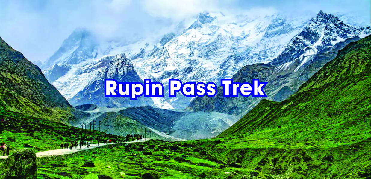
Rupin Pass Trek
A Change in Scenery at Every Turn
Rupin Pass can be described as a cross-country walk full of surprises and varied landscapes around every corner. This high altitude trek is a favourite among adventure-seeking souls and is considered one of India's best trek routes. This trekking route crosses two Indian states at an elevation of 15,250 feet, passing through vibrant natural features and providing breathtaking views along the way.
The Rupin Pass trip begins in Dhaula, Uttarakhand, and ends at Sangla, Himachal Pradesh. The hike route's charm rests in the fact that it allows you to see both the desolate snow-capped Himalayan region and the two extremely different local cultures of the two neighbouring states.
The Rupin Pass has to be considered a classic trek in India. This journey is like an orchestra, gathering momentum with scenery surprises every hour or so. The walk presents a new sight to see and new scenery to unveil with each step. And everything happened so quickly.
U can also read this Bali Pass Trek
The surprises begin on the first day of your adventure. When you see the Rupin River appear around 20 minutes into the trail, it fans out into a wide bed below you. It doesn't end there, either. From here, the trail passes through hanging villages before abruptly plunging into a dense pine forest! That's not all, though. After that, the trail takes you through glacier meadows, snow bridges, glacial valleys, snowfields, and hundreds of waterfalls.
Rupin Pass is a high-altitude hike that begins in Uttarakhand's Dhaula and concludes in Sangla. The majority of your trekking will be done in Himachal Pradesh, as 80 per cent of the trip route is located there. Rupin Pass, at an altitude of around 15250 feet, is one of India's high-altitude trekking expeditions. The varied amount of panoramas and abrupt fluctuation in pathways attract many nature enthusiasts, and the high altitude is not the only reason for its appeal among trekkers.
Rupin Pass Trek will wow you with the amount of variety that mother nature has to offer you every hour. The routes can be tough at times, with steep climbs that suddenly shift to gentle treks. Rupin Pass is a wonderful walk for any adventure because it offers treks on snow, rugged terrain, along with and across water streams, and through meadows. As you near the finish of your walk, you will begin in greener and hotter environments and go to and through the coldest of locations over the snow.

Click Here to know about The Brahama Tal Trek.
Rupin Pass offers you variety in every aspect during your high altitude walking adventure. Throughout the walk, you will encounter a variety of terrain with abrupt changes. From snow-covered fields to rocky terrain; from lush green meadows to deep mountain folds; from glaciers, snow bridges, and icy slopes to habitations and holy sites, this walk has it all.
Although summits are a highlight of most journey routes, trekkers from all over the world have been drawn to Rupin Pass because of its diversity and the experience it provides throughout the trek route. Even though trekking for 5 to 6 hours on average per day while advancing 10 kilometres per day can be taxing for some, the thrill of adventure and the experience it provides, as well as the breathtaking views, make it all worthwhile.
Rupin Pass in India attracts many adventure-seeking souls despite the fact that it is considered a difficult trek in terms of difficulty level. The trek route takes you to snowfields and valleys of lofty peaks with a significant drop in temperature after starting in the greener parts of the region with a moderate temperature.
Buran Ghati Pass Trek to know more click here
About Rupin PassTrek
Rupin pass trek, which stretches across India's two Himalayan states, is a high-altitude trek that offers a spectacular display of natural diversity and natural wilderness. This trek is extremely popular among both Indian and foreign trekkers, and those planning to embark on it this summer can look forward to a fantastic adventure. The journey begins in Uttarakhand and ends in Himachal Pradesh at Sangla, requiring you to cross the state border near Kinnaur to enter Himachal Pradesh.
The Rupin Pass trip, which begins in Dehradun and ends in Dhaula, takes you through little hidden hamlets and past lovely waterfalls. This path takes you to Jhaka's famous hanging hamlet and gives you the opportunity to stand on a snow bridge with the river Rupin flowing beneath you and dropping down the edge of the mountain, making a stunning cascade right in front of your eyes.
As you near the end of the trek, the dense forests of fir, rhododendron, and oak open up to reveal a magnificent view of the Kailash Peak. After the summit day, you pass through Ronti Gad and Sangla on your way to Shimla, where the local culture feels very different from where you started. Your trek will be 52 kilometres long, with stunning scenery to delight your eyes. The Rupin Pass trek is divided into eight days, with each day covering about 7 to 8 kilometres on average.

Click Here to know about the most beautiful trek Roop Kund Trek
As you progress along the trek trail, you will notice a distinct change in landscape and terrain as you gain altitude. The trek begins by passing through Govind National Park, also known as GovindVanyaPashuVihar.
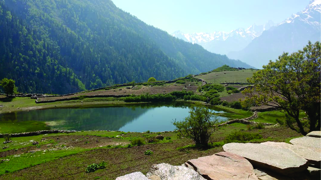
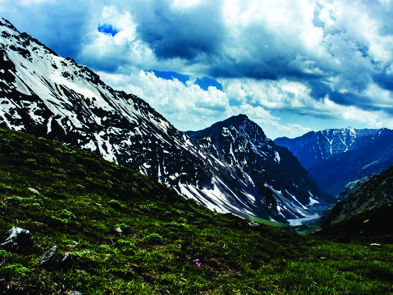
At lower altitudes, the hiking path passes through coniferous trees and small towns and villages that have settled on the banks of stream valleys. As you climb higher in elevation, the fascinating vista of brilliant and richly coloured meadows, also known as Thach; wildflowers in a variety of colours; waterfalls; and wide lengths of ice-covered fields overwhelm you. During the summer, large expanses of land are covered in snow, but during the post-monsoon season, wildflowers bloom along the journey track.
This is lovely and creates a peaceful atmosphere while you enjoy the natural beauties along your trekking route. It's a completely different scene from the top of Rupin Pass. The vista from the pass of the Kinnaur Kailash range and CharangGhati mountains will take your breath away.

The tranquil mood of the Rupin Pass trek is enhanced not only by the abrupt changes in natural characteristics but also by places like PokuDevta temple, a two-story Kinnauri culture shrine near Sewa, which gives an entirely new dimension to the trek. As you climb altitude, your mobile network, like the climate, begins to deteriorate as you pass through distant communities. You can get the required amount of cash from the ATM at Purola, which is on the road to Dhaula, before starting the Rupin Pass walk, as it passes through lonely settlements on its approach to the majestic Himalayan peaks.
Beas Kund Trek is an amazing trek Click Here to know more
Quick Facts about Rupin Pass Trek
Rupin Pass Trek Route
Rupin Pass trek route offers both an adventurous and a tranquil and calming experience. The trail leads to the rich alpine meadows and valleys where mountain peaks surge above Rupin Pass, passing through historic mountain towns that are highly important and have been mentioned several times in Hindu religious books and epics. The region's rugged geography is ideal for those seeking adventure since the trail passes through tough terrain and three different valleys: Rupin, Baspa, and Pin, each with its own distinct feature.
The Rupin Pass trek trail in India takes you along the river Rupin on a trek route. The trail begins in Dhaula, where the rivers Supin and Rupin meet to form the Tons river, which flows alongside and serves as a tributary of the Yamuna. The trail leads you on an exciting trek to the source of the Rupin River. As you walk upstream along the river's banks, you'll notice the river's sharp turns and twists as it winds its way through the mountainous terrain.

Harki Dun Ruinsara Tal Trek to know more click here
Following the river to its source takes you past rural villages in Uttarakhand, such as Sewa, and Himachal's Jiskun and Jaskha. Because the residents of Jiskun and Jakha follow the Satsangi religious sect and live a vegan lifestyle, you will get the opportunity to learn about their culture and way of life. These villagers follow Kinnaur-style traditions and practise, and their homes and dress reflect this.
In Chitkul, you will also pass through the villages of Baspa valley on your last day. To get the most out of your trip, interact with the locals along the trail and in the campsites at Dhaula, SewaJiskin, and Sangla. Learn more about them, their culture, and their history. Trust me when I say that on your journey back home, you will have had an exciting trek with plenty of intriguing stories to tell.
The walk begins at Dhaula's hamlets and continues through Sewa, Jiskun, and Surwas Thatch. This path leads to Dhanderas Thatch and is a lot more comfortable walk than the others, with only a few high climbs and difficult terrain, but it offers the best views of the region.

The Bhrighu Lake Trek to know more click here
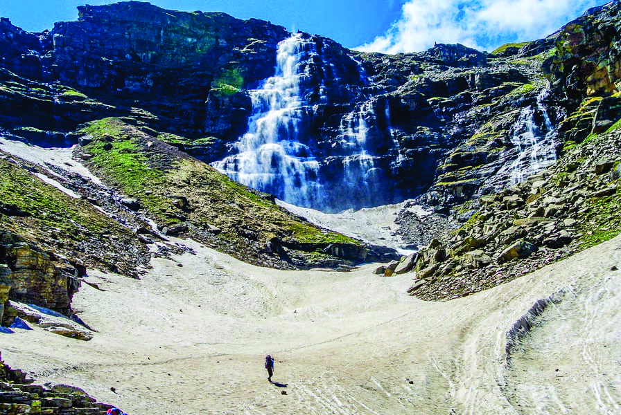
The enthralling waterfall, to which you climb, can be seen from the Dhanderas Thatch campsite. Climbing to the top of the Rupin Pass Upper Waterfall is an exciting adventure in and of itself. The panoramic view from the top is unforgettable. The trek continues from the Upper Waterfall campsite to Ronti Gad, crossing the Rupin pass via the Rati Pheri. The trek concludes at Sanga, which is a long way down from Ronti Gad. You can then take a bus or cab to Shimla.
The difficulty level of the trek
The Rupin Pass trek in India is considered moderate to difficult in terms of difficulty, covering a vast stretch of 52kms in 8 days by trekking 7-8kms per day. It is important to note that the term "difficulty" can be used in a variety of contexts. People who are in good shape and have an active body will often find the trek to be easy and enjoyable, with a peaceful summit climb and descent.
The trek does cover a wide range of terrain, from pleasant, tranquil meadows to rugged terrain and hikes on narrow roads at cliff edges. It also has occasional descents and climbs that can be overwhelming for some but can also be exciting enough to entice trekkers to return to experience something new that the trek has to offer.

CLICK HERE To Explore The Beauty of The Kedarkantha Tal Trek
Surprising discoveries along the way
Views of waterfalls and streams: Throughout the trek, you will come across numerous waterfalls and streams. The best sight you will see at Rupin Valley is thousands of waterfalls flowing down from such a height that they appear to be falling straight from the sky.
Jhaka Village, A Hanging Village: It is a one-of-a-kind village perched on the cliff's edge, giving the impression that it is suspended in mid-air.
Snow Bridges: The sensation of walking on the snow bridges you come across adds to the variety of the treks. On the way, you'll pass through a number of snow bridges.
Lush Forests: The trek passes through forests of fir, rhododendron, and oak at various points. The entrance and exit to the forests are once again so abrupt that you will feel as if you are in a movie set.
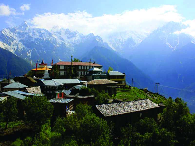
Kinnaur Temple: It is a two-story Kinnauri temple in Sewa that stands out from its surroundings.
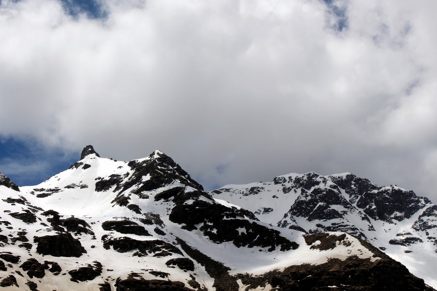
Views of Kinner Kailash: As you near the end of the Rupin Pass trek, you will be mesmerised by the views of the lofty Kailash Peak.

The Most Beautiful Trek in Himachal Pradesh Hampta Pass Trek To know More Click Here.
Itinerary in Detail.
Day 1: Dehradun to Dhaula
Day 1 would include a 10- to 11-hour drive from Dehradun to Dhaula, the trek's base camp. You can travel to Dehradun by overnight train from New Delhi Railway Station. On this route, trains such as the Nanda Devi Express and the Jan Shatabdi run on a daily basis. We will arrange transportation from Dehradun at an additional cost, and you should arrive in Dhaula by the evening. Dhaula, located at an elevation of over 5,100 feet, is a small village in Uttarakhand, and a night's rest here would prepare you for the ultimate journey.
The journey to Dhaula would introduce you to the pure waters of the Yamuna River, which flows through the Himalayan ranges. You'd also get to see a mythical village that worships the Maharbharata's Kauravas. Similarly, the valley's garlanded marigold flower meadows would be a pleasant sight to see.

Triund Trek an amazing trek near Dharamshala Himachal Pradesh
Day 2: Dhaula to Sewa
The second day is all about an easy hike that will require you to walk on various topographic features. It's an 11-kilometre hike that leads to Sewa, your next camping spot. So, after leaving Dhaula village, a cattle shelter would fall in your path, followed by a 200-meter climb to relatively level tracks. As you continue, you will be able to see the Rupin River flowing by.
This leg of your journey would take you through apple and apricot trees and provide a mesmerising view of Rupin falling from a high cliff. Given the moderate difficulty of the trek, it would be a pleasure to enjoy the pleasant weather and some snacks with tea as you approach Sewa. You can also visit the famous Kinnaur Temple in Sewa before ending your day with a night at a homestay. This section of the trek takes about six hours and takes you to an elevation of about 6,300 feet.
Day 3: Sewa to Bawta
Your third day will consist of an exciting 6-kilometre (4-hour) hike. You walk out of your Sewa campsite early in the morning and make your way to Bawata. Because today's trek trail is a bit difficult, you will be given instructions on how to have an enjoyable trek day with the least amount of difficulty. In every way, today's trail is exciting and adventurous. With treacherous terrain that is slippery and prone to landslides, it is critical that you exercise caution while trekking.
As you walk out of Sewa, you will pass through mixed cross fields before entering a dense dark jungle. The change in vegetation is fascinating and adds to the sense of adventure. Today's trek will consist primarily of a 3-hour moderately difficult walk and a 1-hour steep ascent near the end. As you make your way through the jungle, hopping across the various rivulets and streams, you will come to a wooden bridge known as No Man's Place. It is not part of any particular state's territory.

After a short hike, begin your steep ascent to Bawata through the lush mountain vegetation of Deodar and Walnut trees. After finishing the day's trekking, you arrive in Bawata and spend the night in a homestay.
Click Here to Explore the Beauty of the Satopanth Glacier Trek
Day 4: Bawta to Jhaka
The fourth day of the trek consists of 5 kilometres of trekking from the Bawta campsite to Jhaka, with Selwan Khad serving as your final water point. Today's trek allows you to gain 8,700 attitude points in about 4 hours. Having said that, the ascent to Jiskun is still moderate, and you must descend to reach the new wooden bridge, where you will wonder how a trail like this was cut out of a rock face.
Your climb to Jhaka is quite interesting and entertaining, with the trail terrain and surroundings changing abruptly. Hiking through the mixed dense forest with the cliff on the other side begins with a zig-zag trail. It is a gentle walk to the quaint village of Jhaka, whose people have adopted the Satsang way of life. People here regard animals as sacred and avoid eating meat. Restock your supplies here, as this is the final and highest village on the Rupin Pass trek.
Day 5: Jhaka to Dhanderas Thatch
Your day begins with a beautiful atmosphere at the Jhaka campsite during the sunrise. On the fifth day, you walk out of the campsite to complete 11 kilometres of trekking in 8 hours. We pack lunch for the day with the goal of gaining 11,680 feet of altitude.
Your path to Dhanderas That takes you through fields and into a mountain forest. As you walk through the forest trail, you come to a fork that leads to a section of the trek that is covered in snow patches, and you soon come across a snow bridge that crosses the river Rupin. From here, the narrow trail leads to another wooden bridge. The surroundings, the river, and the terrain have engulfed you in a sense of adventure by this point. You enter another dense Rhododendron forest as you cross streams and walk on rocky terrain and boulders with the river on your left.
As you make your way to Saruwas Thatch, you are surrounded by nature's splendour. You can take your time admiring the various shades and hues of nature, with a distant view of the Rupin waterfall. As you progress, you will be surrounded by sacred silver birch trees or Bhoj Trees until you reach the forest. According to legend, the Ramayana was written in the leaves of these trees, thus making them sacred.
You'll enjoy a fantastic view of thousands of waterfalls gushing down to meet Rupin as you hike up to the U-shaped valley. The view of the land is equally fascinating, as in the green parts the wilderness is filled with yellow marigolds and with all its strength and grace, the river Rupin flows from its source.
You get to the middle of a valley, Dhanderas This, as you go down through the lively green and yellow wild meadows, woodlands and showplaces. Experience the panorama and the campground in one of Himalayan's most important weeds.
Day 6: Dhanderas thatch to Upper Waterfall camp or Rati Pheri camp
On Day 6, you would have to climb 1.400 ft and there would again be many rivulets and waterfall on this little hike. And in view of the weather, Dhanderas Thatch acclimation is really vital for one to move on. So you would climb up to the top of a waterfall for some acclimation after having breakfast. The training will also test your snow-hiking skills so that you can prevent serious mistakes and make a hard journey to yourself.
You will also be able to utilise the ice axis, walking pole and slide on the snow along the route to the peak of the waterfall from its foot. These tactics for snow trekking would occur to you if you were to carve your way to a large snow bridge. Standing in the centre of the snow bridge, watching Rupin dissolve under your feet, after going over the cascade over you, would be a spell-bound event. You will find a huge wave, which is your camping place for the day when you reach the top of the waterfall. You can see here many streams pouring down the mountains of the Rupin River.
Day 7: Upper Waterfall camp to Ronti Gad, crossing the Rupin pass via Rati Pheri
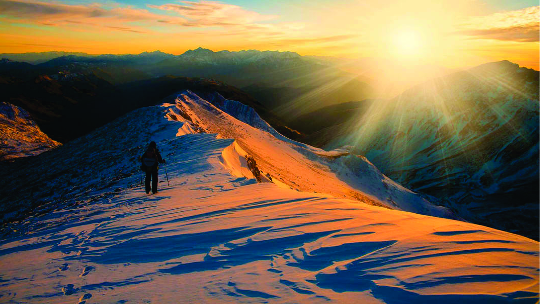
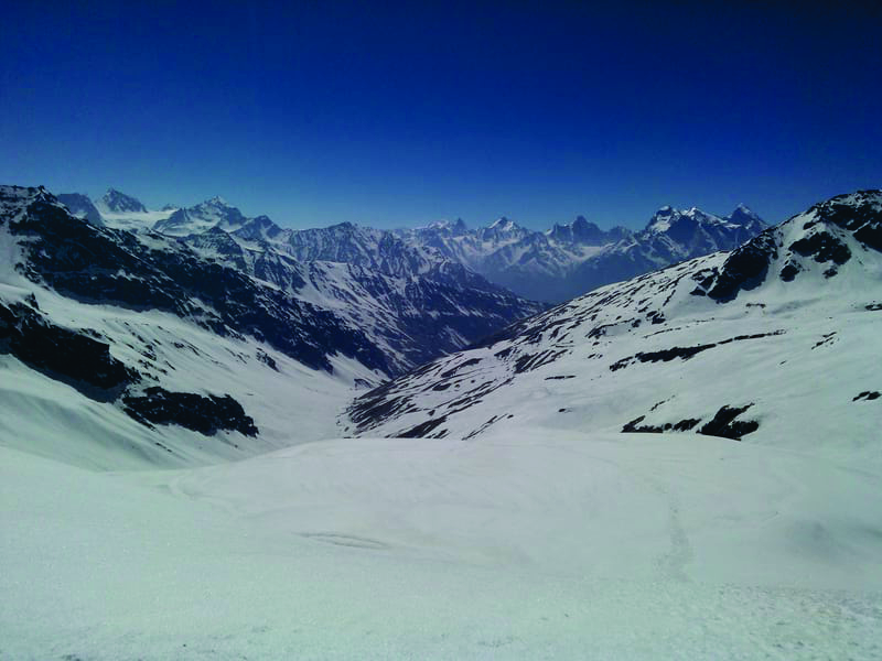
This will be Rupin Pass's longest and likely most tough section. The height is 15.400 ft from 13.100 ft, and a severe decline to 13.100 feet is followed. Since the water supplies are limited, refilling your bottles at the Rati Pheri campsite would be vital.
It begins with an hour of difficulty rising from the Upper waterfall that will take you to the Camping Rati Pheri. At this spot, just the snow stretches can be seen across the site. You would walk to the Rupin Pass gully through those snowy paths. But it may prove quite difficult and attractive to cross the limitless snowfields with a view of the Rupin Pass at a considerable distance. Given the lack of well-defined trails, you could need to take appropriate precautions when walking on the snow, given that slips and slides are relatively typical. Sense of guidance is just as vital. It would be a nice hike from the Rupin Pass to Ronti Gad, followed by a climb.

Day 8: Ronti Gad to Sangla
The third day of your hike is a full drop to Sangla which means that you will fall in six hours from 13100 ft to 8600 ft. This demonstrates how difficult it can be for your knees and toes in particular. The views of the Kinner Kailash mountain and Sangla Kanda Lake would be visible on the scenery and nature's splendour.
It begins with a descent of 1500 feet, leading to the enclosed valley of Ronti Gad. Following this is a trip to Rukti Gad. The vistas of Sangla Kanda Lake and Kinner Kailash Range offered a wonderful spectacle of the Himalayas with Rupin Pass now completely out of sight. You will also be able to see the villages around Lake Sangla Kanda and stop in any of these settlements on your way.
A multitude of paths takes you to the terminus of the Rupin Pass Trail from Sangla Kanda. You would have to go through blue pine forests where a brief ascent would take you to Sangla via Baspa Village for half a height of severe down. From Sangla to Shimla, private cars routinely travel a little more than nine hours via NH5.
Best Visit Time
Since it is a crossover, in the summer or after the monsoon it is always advisable to visit. Although open all year-round except during the rainy season (for landslides and slippery trenches), due to good weather conditions, this summer season has proven to be the favourite of all trekkers. Trekkers prefer to visit Rupin Pass between the middle of April and June and between September and October.
Most important of the trek
The start and finish point of a distinct Rupin Pass Tour and the intertwining and transition from one local custom and culture to another may be found in two different states. Dhaula, the hamlet in the Himachal region, is the base camp of Rupin Pass. The first day of the tour will lead you through the forests with rhododendrons, firs and oak and apple and apricot trees which will enhance the view of the river Rupin. Not only that, you will also feel the peaceful atmosphere of the wide meadows.
On the second day, you travel the two states and frequently witness topographical variations. As you walk through woodlands and go down to streams and streams, Haldi Khad is on the bank of the river. You are thrilled to discover the sights, and on the way to the settlement of Jiskun, you can see the Rupin River on the outskirts of the cliff.
The Suruwas Thatch campground is noted for its panoramic views. The valley and Rupin Waterfall are all visible. You get it abundantly on the Rupin Pass trip if you look for streams, waterfalls and rivers. In the rough landscape, you will find countless waterfalls. This hike is not only the way to the peak of the waterfall with an ice axe and a walking pole, from the base or the lower cascade.
The walk is in all ways an adventure. On the top of the waterfall on a large wild meadow, you find the campground at the Upper Waterfall. Here you can see different little streams uniting into the Rupin River, which flows down from the highest point into the horizon after the flooding of the waters. It's a viewing experience that's imbued with every walker's mind. Then, you feel your whole work is worth it on the walk. The breathtaking view of Kinner Kailash will render you awestruck as you reach there near the finish of the trip.
The whole trek will be marvellous woodlands and oak, fir trees, gold leavened maple and rhododendrons with various other coniferous trees. The track will be completed with trees. The beauty of trekking on the Rupin Pass is that it does not only allow you to experience snow during an adventure journey across hard terrain but also that you must cross a snow bridge to reach the opposite side of the Rupin. It is a wonderful feeling, as the river rushes underneath the bridge, and the boulders under your feet are falling over one another.
How to get to the Rupin Pass
Dhaula is the base camp for the pass of Rupin. However, as Dehradun is a more accessible place, we arrange a pickup from Dehradun ourselves. For additional details, you can contact our team.
By Air: Jolly Grant Airport, Dehradun via Flight Nearest airport. Several bus and cab options are available to Dhaula via Mori from the airport. It's a lovely 198km journey from Dehradun for 7 to 8 hours.
By Train - Haridwar Railway Station and Dehradun Railway Station - Nearest Train Station. Several bus services and cab services are available via Mori from the train station to Dhaula. It is a lovely 198 kilometres travel from 7 to 8 hours.
By Road: Dehradun can be reached by road from all major towns of India and bus service from most important towns in India is available. You can choose a bus or a cab after reaching Dehradun since a range of bus services and cab services to Dhaula can be obtained through Mori. It is a lovely 198 kilometres travel from 7 to 8 hours.
Reasons why you cannot miss the Rupin Pass Trek.
It's crucial to understand that the Rupin Pass trip is one of the few treks in the world that allows you to explore several paths at different times.
The birth of two major rivers, the Yamuna and the Satluj, can be seen from Rupin Pass. If you are a nature lover who enjoys exploring new areas, then this walk is for you.
You'll pass through mountainous terrain, gorgeous meadows, spectacular glaciers, beautiful snow bridges, and water streams on your way to the summit.
The beautiful vista of Kailash Peak will wow you as you approach the end of your hike.
Comments
Post a Comment
If you have any doubt please let me know