Valley of Flowers Trek About Valley of Flowers The Valley of Flowers lives up to its name, with an endless supply of flowers in full bloom. The journey could even be renamed a floral fairytale romance! The Valley of Flowers' unique landscape is like a dream come true: an exquisite valley bejewelled with a never-ending stretch of flowers. Between the rocky mountain ranges of Zanskar and the Great Himalayas are lovely meadows studded with indigenous alpine flora. The area, which is a UNESCO World Heritage site, was designated as a national park in 1982. The endless stretch of gorgeous vegetation, dotted with colourful blossoms of pink, yellow, purple, red, blue, and orange hues, is the highlight of this excursion. Throughout the hike, the fragrant scent of the carpeting flowers entices you. Botanists, flower lovers, bird watchers, wildlife photographers, hikers, environment enthusiasts, and adventure seekers from all over the world are drawn to the valley's unspoiled beauty. It...
BEAS KUND TREK MANALI

Are you planning a little weekend getaway or outdoor activities such as hiking and
trekking? Looking for a simple Himachal
trek? Are you familiar with the Beas Kund Trek? If not, then continue
reading this article. But first, tell me about your favourite way of seeing a
new place. Drive through it, talk to the people who live there, learn about
their culture, wander about, or travel along a river's bank in quest of its
source?
Beas Kund has long been a
popular trek in the Manali area.
After all, it leads directly to the mouth of the river that runs through town.
(You may have followed the same river upstream on your way to Manali.)
The setting, though, is one of the reasons trekkers enjoy this trek. Consider the
following scenario: Below the tops of Manali's three largest mountains, lush
green pastures thrive. The emerald lake, from which the river Beas comes, is
also hidden in these grasslands.
SUGGESTED READ : HAR KI DUN RUINSARA TAL TREK

This
Beas Kund Trek takes you through the
beautiful green grasslands and majestic mountains of Manali, making for an
exciting trekking adventure. Soothe your senses with views of the lovely lake
through which the river Beas emerges, and catch a glimpse of the river's
crystal clear waters, set within the eye-catching PirPanjal mountain ranges.
Witnessing
the birth of a well-known mountain river, as well as its voyage and mythology?
Without a certain, the Beas Kund Trek in
Manali will match your schedule because it takes two days longer than a
typical weekend excursion (4 days). It has plenty of natural beauty to nourish
your eyes and re-energize your soul.
The beauty of his environment is enhanced by the juxtaposition of this calm water
body tucked between rugged mountain peaks of the PirPanjal range.
CLICK HERE TO EXPLORE THE BHRIGU LAKE TREK
Standing
here, you get a strong impression of being close to the source of the flowing
river in the valley below. This green kund splits into streams with cascading
cascades till it reaches the scorching Beas river.

The
Beas Kund, like every river that supports a civilization or the communities
that surround it, is steeped in folklore.
Rishi
Vyas, the author of the Mahabharata, is said to have had his regular bath in
this lake. It's probable that the name Beas Kund comes from the words Vyas,
which means sage, and Kund, which means lake.
Everyone
is drawn to this walk because of the large snowy summits that loom over you,
the greenery of the grasslands, and the lake.
While
this walk is suitable for novices, we recommend that you prepare ahead of time.
The ascent from roughly 8000 feet to over 12,000 feet at the start of the hike
is no easy task.
ALSO READ : KEDAR KANTHA TAL TREK
Conquer
Himachal Pradesh's huge mountains and reaches a height of 3,810 metres to see
summit views of Manali's large mountains like Friendship Peak, Shitidhar, Ladakhi, and Hanuman Tibba.

If
you're lucky, you might catch sight of Mt Indrasen, DeoTibba, and other peaks
from the PirPanjal range. When you spend the chilly night stargazing at the huge expanse of star-studded night skies in your tent during the thrilling trekking trip, you'll have a wonderful camping session.
The
Beas River rises on the eastern slopes of the Rohtang La or Rohtang Pass in the
PirPanjal Range of the Himalayas, and is considered sacred by the local hill
people. The river originates at an elevation of 12772 feet. The Beas Kund in Manali is the source of
the mainstream, which joins numerous other Himalayan streams to form the
Beas river. In Palachan hamlet, north of Manali, mountain streams from several
sources unite to produce the Beas river.
CLICK HERE TO EXPLORE THE BEAUTIFUL HAMPTA PASS TREK
Before
entering Pakistan, this 470-kilometre-long river passes through Himachal
Pradesh and Punjab, merging with the Sutlej at Harike in Punjab. In the Vedas,
the river is referred to as "Arjiki." It is thought to have been
named "Beas" after the great sage Ved Vyas, the author of the
well-known Indian epic Mahabharata. Many tourist attractions such as Manali,
Kullu and Kangra valley have grown along the banks of the Beas River, which is
particularly significant to the economy of Himachal Pradesh.

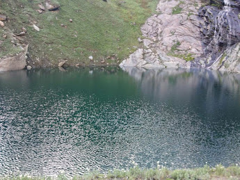
Beas
Kund, a scenic lake nestled in the Himachal Pradesh's Dhauladharmountain,
located 3 kilometres from Bakar Thatch meadows. The views of the snow-capped
mountain top, lush green Bakar Thatch meadow, massive glacier, and calm
Himachali villages are breathtaking during the trek to the Beas Kund from
Manali. You'll stop in Solang Valley along the trip, which is known for
adventure activities like paragliding and parachuting.
Location Of Beas Kund
Trekkers
go to Manali's Beas Kund, which sits at
an elevation of 12772 feet. This lovely alpine lake is surrounded by the
PirPanjal mountain range, Friendship peak, Hanuman Tibba, and ShetiDhar peak. The distance between Manali to Beas Kund is
approximately 17 kilometres. The Beas Kund walk-in Manali is simple and
suitable for beginners.
THE MOST BEAUTIFUL TREKS OF UTTARAKHAND
Mythology related to Beas Kund
Beas
Kund, like many other Himalayan locations, is mentioned in Hindu mythology.
According
to legend, after losing his son Shakti, rishi Vashisht committed suicide by
plunging into the Beas River. The river, on the other hand, refused to let him
drown in its waters. This event left Sage Vashist speechless, and he began to
reside on the shores of Beas Kund.

Rishi Vyas, the renowned sage and author of the
Mahabharata used to bathe in this lake and
meditate every day on its bank. As a result, the Beas Kund Lake is revered as a
sacred site.
Best Time to Visit
During In the winter, Beas Kund is blanketed by several feet of snow, especially from
December to February. As a result, it's best to avoid trekking in this area
during the winter. These three months, from May to July, are the greatest for
exploring Beas Kund's trails.
Because
of excessive rainfall, the trail to Beas
Kund in Manali should be avoided from August to September. As a result,
landslides and overflowing rivers are common. Even yet, with careful planning
and past experience walking in the rain, this trek may be completed during the
monsoon.
During In the months of March and April, the trail is covered in waist-deep snow, and
sight is limited. Trekking
is much more difficult during this time and you should have snow gears to trek.

Reaching base for the Beas Kund
Dhundi serves as the trek's starting point.
You must travel through Manali to get to Dhundi.
How to reach Manali by road
Manali is well-connected
with most of the major cities of India like Delhi, Mumbai, Kolkata, etc. by
road. There are Volvo bus services available from Delhi as well. You can
book a bus to Manali from Delhi. The road trip from Delhi to Manali is around
550 kilometres long and takes 12 to 14 hours.
By
road, Chandigarh is 307 kilometres from Manali. The bus is one of the best ways to get from Chandigarh to Manali.
There are several direct buses, and the journey time is usually around 7 hours.
Taking a cab from Chandigarh to Mandi and then a bus from Mandi to Manali can
save you time.
Some
booking apps allow you to book bus seats in advance of your journey.

How to reach Manali by air
Kullu-Manali The airport in Bhuntar is the closest airport. Bhuntar is about 50 kilometres from
Manali. Manali may be reached via taxi or cab from the airport.
How to reach Manali by train
The nearest railway station to Manali is Joginder Nagar Railway Station. However,
major Indian cities such as Delhi, Mumbai, and Kolkata are well connected to
Chandigarh and Ambala stations. Taxi services to Manali are available from all
of these stations.
YOU CAN ALSO READ THE STOPANTH GLACIER TREK
YPR
Samparkkranti Express is available from Bangalore. Kalka mail runs from Kolkata
to Chandigarh. The CDG BDTS SF express connects Ahmedabad and Chandigarh.
Indore to Chandigarh railway station is served by the Chandigarh express.
Now,
from Manali, take a taxi or take a bus
to SolangNallah, which is 12 kilometres from Manali town. SolangNallah is a
lovely location with a lovely landscape. Many popular treks begin here.

From
SolangNallah, you can either walk to Dhundi, which is around 8 kilometres
distant, or hitchhike using the passing automobiles.
The route of the Beas Kund Manali Trek and what to look
out for The Beas KundManali
Trek begins in Manali town.
The trail passes past SolangNallah and Dhundi before arriving at Bakarthatch
Meadows and Beas Kund.
Tourists
and trekkers flock to this well-known highland station. This is because many
trekking treks begin at this British-era hamlet.
There are many locations to visit if you wish to remain for a day or two and scout around the town. Visit Hidimba Devi temple, ManikaranGurudwara, Manu temple, and Jogini waterfall to feel a spiritual and powerful positive atmosphere. Around Manali, the Himalayan National Park, Van Vihar, and the Beas River are some of the natural wonders.

The town of Old Manali is well-known as a tourist destination for its vintage-style residences and stores.
SolangNallah
It is a small valley located 14 kilometres northwest of Manali at an elevation of 8400 feet. Solang
is well-known for its winter sports and activities. Tourists throng here in the
winter to experience the adrenaline thrill of adventure snow sports. In the
winter, the snow-covered valley's principal recreational activity is skiing.
When
the snow melts in the summer, zorbing, horseback riding, paragliding, and
parachuting are all popular activities. The ropeway service is available. From
a significant height above the earth, you can take in the scenery.
The trekking and hiking for the Beas Kund journey begin
here, at Dhundi. From Solang to Dhundi, there is
a well-built road. Some trekkers walk this path, while others drive to Dhundi
and begin their journey from there.
If
you wish to go to Dhundhi, hitchhike on one of the many vehicles heading
towards the Rohtang tunnel building site at Dhundi. This route is closed to
private and public vehicles for the duration of the construction.

Dhundi
Dhundi
is a small village located 8 kilometres north of Solang Valley. In the Solang valley, it is the last settlement. It
is the confluence of the Beas River and its first tributary.
The
green meadow section of this walk begins at Dhundi and continues up to the
Bakarthatch area.
If
you have time in Dhundi, the weather observatory is a nice place to visit if
you want to explore the area.

The way from Dhundi to Bakarthatch
The 4km route from Dhundi to Bakarthatch is on a well-trodden trail with the Beas
river on your left side. The variety of flowers and their range of hues on the
right side will brighten your day.
You'll have to cross the Beas river a few times along the
journey. Crossing full-fledged alpine streams can be
dangerous and difficult. Maintain your balance and only take a step forward
when you have a firm grip on the rock beneath your foot. If you're nervous,
seek assistance from other trekkers.
You'll
see a lot of BhojPatra or Birch trees along the journey, which are high
elevation alpine trees. In ancient times, its bark was used to write on. The
trail takes a right turn as the BhojPatra meadows come to an end. After a
half-hour hike, you'll arrive at Bakarthatch.
During
this section of the Beas Kund Trek Manali, Himalayan peaks such as Indrasen,
DeoTibba, Friendship Peak, and Hanuman Tibba may be seen.

Bakarthatch
At a remarkable altitude of 10,800 feet, Bakarthatch is a lush green velvety meadow.
Shepherds are frequently seen grazing livestock and cattle. Thatch signifies
meadow in the Gaddi community or Shepherds dialect. It's one of the camping spots on Manali's Beas Kund Trek.
From
Dhundi to Bakarthatch, the meadow is carpeted with rare and exotic Himalayan
flowers such as Rhododendron, Marsh Marigold, Himalayan Thistle, and wild rose,
to name a few.
The final section of the Beas Kund Trek Manali begins
with flatland hiking from Bakarthatch.
However, as you get closer to the boulder field, the terrain grows steeper. You must cross the gushing Beas river
several times, stepping through boulders.
Cairns
(a stack of stones perched on top of one another) are widespread on boulder
surfaces in this area. When visibility is reduced owing to rain or fog, these
cairns indicate the correct path.
After about 15 minutes of climbing, you'll
start dropping and enter Beas Kund Valley. The Beas Kund glacier may be
seen from the Dhundi to Bakarthatch trek even before you arrive. This valley
has no slope, and a number of mountain streams flow down through the flat valley.
You
can see the first glimpse of the Beas Kund by trekking a little further into
the valley.
When
you plunge your feet in the ice-cold water of the sacred lake, the strain of
trekking from Manali to Beas Kund will vanish away.
Tips for the trek
Carry
some refillable water bottles because there are many pure water streams along
the way.
Raincoats,
waterproof bags and plastic bags should all be carried, especially during the
rainy season.
The
weather in this area is notoriously fickle, so bring plenty of warm clothing.
Also, make sure you have all of your necessary medications with you.
Carry
some light snacks and energy bars with you to eat in between meals. Vegetarian
food is provided at every campsite. During the hike, the only egg is served as a non-vegetarian meal.
The sun shines brightly in the higher altitudes you will be climbing on your walk,
so bring sunscreen, sunglasses, and hats.
Carry
a separate plastic bag for all your non-biodegradable and plastic rubbish. As
hikers, we must respect the mountain's sacredness and cleanliness.
Highlights about Beas Kund Trek
• You may
see breathtaking scenery, including majestic mountains, forests, grasslands,
and inviting valleys, as well as a spellbinding vista of a glacier-fed lake.
• A
close-up view of the Pir Panjal range's great mountain ranges and summits,
including Friendship Peak, Shitidhar, Ladakh, Hanuman Tibba, Mt Indrasen, Deo
Tibba, and a few others.
• Several tiny streams will
be visible during your walk.
• The Vashisht Temple is worth a
visit.
• You'll be able to connect with
the locals and learn about the region's folklore and legendary traditions.
Quick Facts
- Kullu Valley and Pir Panjal Range (region)
- Trek Altitude: 12,772 feet
- Trek Difficulty: Easy
- Trek Duration: 3 Days
- Total Distance: 47 kilometres (approx)
- Starting Point- Manali
- Ending Point- Manali
- Base Camp- Manali
- Best time to visit- June to September
Temperature- Summers are comfortable, with temperatures ranging from 20 degrees Celsius to 3 to 4 degrees Celsius, however, the temperature drops after sunset. When it snows in In the winter, the temperature is guaranteed to drop below 0 degrees.
Nearest Railway Station– Jogindernagar Railway Station • Nearest Airport– Bhuntar Airport • Last ATM– Manali
Conclusion
The
Beas Kund Trip is a well-known trek that is suitable for beginners. Even in the
monsoon, with a little more planning, prudence, and instruction, it is
possible.
Also,
the distance between Manali and Beas
Kund can be covered in four days, so there's no need to take a long
vacation from your busy schedule. As a result, it's a simple, beginner-friendly
short hike with spectacular vistas. Beautiful and uncommon species of flora and
fauna adorn the sceneries and the trail. Is there anything else you require?
So
take your time, pack your bags, and travel from Manali to Beas Kund. In this
piece, I've provided all of the relevant information you'll need for planning
and on the road.
Comments
Post a Comment
If you have any doubt please let me know