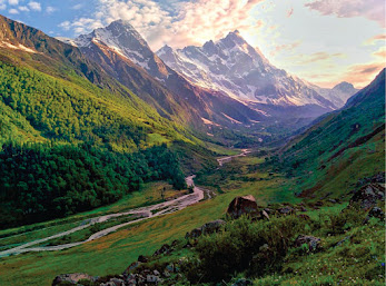
Valley of Flowers Trek About Valley of Flowers The Valley of Flowers lives up to its name, with an endless supply of flowers in full bloom. The journey could even be renamed a floral fairytale romance! The Valley of Flowers' unique landscape is like a dream come true: an exquisite valley bejewelled with a never-ending stretch of flowers. Between the rocky mountain ranges of Zanskar and the Great Himalayas are lovely meadows studded with indigenous alpine flora. The area, which is a UNESCO World Heritage site, was designated as a national park in 1982. The endless stretch of gorgeous vegetation, dotted with colourful blossoms of pink, yellow, purple, red, blue, and orange hues, is the highlight of this excursion. Throughout the hike, the fragrant scent of the carpeting flowers entices you. Botanists, flower lovers, bird watchers, wildlife photographers, hikers, environment enthusiasts, and adventure seekers from all over the world are drawn to the valley's unspoiled beauty. It...

Crossing Most Adventurous Pass fromHar Ki Dun Valley towards Yamunotri
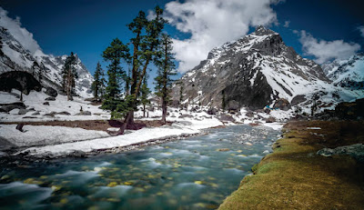
It's uncommon to find a trek that allows you to experience the majesty of a Himalayan pass crossing. Har Ki Dun Valley and Yamunotri are linked by the Bali Pass. It crosses the Tons-Ruinsara river confluence and enjoys the unspoiled serenity and lush meadows of Devsu Thach.
The greenery will soon give way to alpine zones. At 16,207 feet, the Pass provides 360° panoramic views of the Bandarpoonch and Kalanag peaks. This trek is not for the faint of heart, and it is strenuous.
Do you want to combine the thrill of an expedition with a mountain rendezvous? Bali Pass is the way to go, baby! The Bali Pass experience can be summarised as follows: "You don't need magic to disappear; all you need is a destination!" Bali pass is the ideal destination that will leave you speechless and later transform you into a storyteller.
Buran Ghati Pass Trek is the most beautiful trek to explore click here
Dehradun, Uttarakhand's pulsing capital, serves as a gateway to a plethora of strange treks. Trekking in and around Dehradun offers avid trekkers unrivalled views of snow-capped pointed peaks as well as the mystical beauty of nature in the wild. This distinguishing feature makes Dehradun an ideal starting point for a variety of treks and other outdoor pursuits.
The Bali Pass trek emphasises the numerous sides and faces of the Himalayan Pass. The Bali Pass, at an elevation of 16,240 feet, connects the pristine Yamunotri valley to the enthralling Harki Dun valley. The trek begins in the Sankri village. This trek is popular among hikers because of its exhilarating trail and panoramic views of the majestic Kala Nag, Swargarohini, and Bandarpoonch Peaks.
The highlight of the Bali Pass trek is the changing landscapes from pine and fir forests to riverside camps to the surreal villages of Har Ki Dun valley to the connection to Yamunotri valley to beautiful waterfalls to the alpine lake of Ruinsara to meadows overlooking Swargarohini peak and Bandarpunch ranges to snow-capped mountain tops and base camp and a thrilling high altitude summit-like crossing. During Bali Pass trekking, you can see some of the wildlife of the Uttarakhand Himalayas, including monals, Himalayan ibex, and the endangered brown bear. Also, get a close look at Kalanag (Black Peak). Spend an entire day walking across the two delightfully pretty meadows of Ruinsara Lake.

To Know About The Roopkund Trek CLICK HERE
The sublime alpine meadows of Dev Thach, located in the Ruinsara forest, are the main attraction of the trek. The vast meadows are surrounded by towering trees and massive peaks. The grandeur and indescribable beauty of Ruinsara Lake, nestled in the Swargarohini range, entices trekkers to embark on this difficult yet rewarding journey. This trek, in addition to the beauty of the virgin landscapes at their best, provides an opportunity for inner rejuvenation bordering on the spiritual. It gives you more inner strength as you pass through the divine Ruinsara Lake and the Yamunotri Shrine.
This challenging yet rewarding trek is a once-in-a-lifetime opportunity that pampers you with a delectable mix of trekking ingredients. The unrivalled highlights of this high altitude rocky pass are historical temples bedecked with unique architecture, thriving meadows, 360-degree views of majestic Himalayan peaks, enticing campsites, tricky trails meandering next to mountain rivers and lined with wild blossoms, and sacred glacial lakes. In a nutshell, Bali Pass will leave you with an unforgettable trekking experience that you will remember for the rest of your life.
The varied terrain of Bali Pass provides an excellent foundation for trekking enthusiasts who want to take the next step toward expeditions in the future. Let's take a quick look at some interesting facts about the Bali Pass trek.

CLICK HERE TO KNOW ABOUT THE MOST BEAUTIFUL TREKS IN UTTARAKHAND
Some facts about the Bali Pass Trek
Region- Garhwal Himalayas, Uttarakhand
Maximum Altitude- 16,240 feet
Bali Pass Trek Difficulty Level- Difficult
Duration- 8 days
Bali Pass Trek Distance- 64 km
Start Point- Sankri
End Point- JankiChatti
Best Season- May to June and September to October
Temperatures in these months- Plus 25 degrees maximum to -10 degrees minimum
Highlights of Bali Pass Trek
Jaunsar Villages- The villages of Sankri, Osla, and Gangad transport you back in time with their distinctive culture and beliefs. Locals here believe they are Kauravas' ancestors and worship Duryodhana as their God. The wooden-stone architecture and beautiful carvings of these villages' temples are part of Uttarakhand's architectural heritage. The idyllic setting, exquisite beauty, and serenity of these mountain villages will take your breath away. The simplicity of the villagers will enchant you; in addition to experiencing local culture, you will have the opportunity to sample local delicacies and delicious mountain tea.
Beautiful mountain rivers- The effervescence of the Yamuna, Tons, and Supin rivers enliven you. The journey begins in the Tons River Valley and ends in the Yamuna River Valley.
Exotic wildlife and lush vegetation- The trek takes you through Govind National Park, where you can see wildlife such as Langoor, Wild Fox, Indian Crested Porcupine, Yellow Throated Marten, Wild Boar, Black Bear, and Bharal, the mountain goat. Mountain birds such as the Koklass Pheasant, the Brown-fronted Woodpecker, the Scaly-bellied Woodpecker, the Crested Kingfisher, the Himalayan Swiftlet, the Himalayan Griffon, and the Russet Sparrow chirp all the way.
Vast meadows- The alpine meadows of DevshuBugyal are hemmed in by tall trees, and the lofty mountains of Swargarohini and Kalanag stand tall in the background.
Brahma Kamal- This legendary flower is difficult to find in the Himalayas, but the Odari campsite on the Bali Pass trek provides you with the life-giving flowers of Brahma Kamal.
Splendid Views- The Bali Pass trek offers stunning views of Supine Valley as well as 360-degree views of the sacred Swargarohini, Kala Nag, and Bandarpoonch.
The star attraction of the Bali Pass trek is the sacred Ruinsara Lake, which is framed by the Swargarohini peak. During their exile, the Pandavas frequented this region, according to legend. Another highlight of this historic high altitude trek is the Yamunotri Temple, a Hindu pilgrimage site. One of the four Chota Char Dhams is this temple dedicated to Goddess Yamuna. Yamunotri is the source of the Yamuna, Hinduism's second most sacred river.
Camping- This is one of the few legendary treks that allows you to camp at an incredible elevation of 13,452 feet.
Bali Pass- It's a thrilling experience to navigate the tricky trails ahead of Odari with quick manoeuvres. The colossal peaks and frozen SaptarishiKund are a sight to behold as you approach the pass. From the top of the pass, the velvety DyaraBugyal is visible.

SUGGESTED READS: SATOPANTH GLACIER TREK TO KNOW ABOUT THIS CLICK HERE
Detailed Itinerary
Day 1: Dehradun to Sankri
1,950m/6.400ft (Sankri)
Distance: 220 km - approximately 10 hours.
Available network BSNL (erratic).
fterPulora keep a warm jacket handy.
There is a local market.
Pulora has an AMT that is fully functional
Sankari is at the end of the road to GovindBalabh Pant Wilderness Sanctuary.
Reach Sankri, a lovely hamlet 210 kilometres from Dehradun. It is located in Uttarkashi's Govind Pasha National Park. On the first day, you explore the small village, learn about the local culture, and enjoy the flora and fauna of GovindBallabh Pant National Park.
From Dehradun to Sankri, you can take a private taxi or a bus. This 210-kilometre journey through beautiful Himalayan terrain takes about 6 to 8 hours to complete. The road from Dehradun to Sankri via Mussoorie passes through Yamuna Bridge and Tons Valley. The GovindBallabh Pant National Park, which is home to a variety of flora and fauna, is entered at Naitwar. Musk deer, brown bear, snow leopard, and Bharal, as well as colourful orchards and stunning wildflowers in pine and deodar forests, will captivate the wildlife enthusiast in you. The Bali Pass trek route begins in Sankri and concludes in Jaan Ki Chatti.

YOU CAN ALSO READ THIS. THE KEDAR KANTHA TREK
Day 02: Sankri to Seema via Taluka
Altitude: 2,600m/8.500ft (Seema), and 2,100m/6.700ft(Taluka).
Altitude difference: 650m/2,100ft.
Sankri to Taluka drive 12kms, 1 hour.
Taluka-Seema Trek 12km, 7-8 Hours
The majority of the trail is a gradual ascent.
Take a walk along the Supin River.
Trekking is done in the forest of Deodar, Bamboo, Wild Roses, Irises, and Chestnut.
Water on the road.
Osla village is located opposite Seema.
You take a taxi from Sankri to Taluka (6,913 feet). It takes about an hour to travel the 12 kilometres to Taluka. This lovely village is nestled beside the Supin River and features two-story wooden houses with distinctive architecture. The primitive lifestyle of the people here transports you to a time when modernity had not yet arrived. The people of this village worship Duryodhana and believe that they are Kauravas' descendants.
You begin your trek after a hearty breakfast in Taluka. The trail travels along smooth paths through dense forests of willows, walnuts, chinars, chestnuts, and other conifers. Walking through dense woodlands allows you to see rare animals and birds, including the state bird of Uttarakhand, the "Himalayan Monal." Traversing the trail while listening to the chirping of avian species is a once-in-a-lifetime experience. On the way, you can also admire the beauty of silver waterfalls.
This path continues until you reach Gangaar village. A short walk and a river crossing over a wooden bridge will take you to the Seema campsite. This campsite is located directly across the street from the picturesque village of Osla. Spend the night in tents at the Seema campsite.

Day 3: Seema to Rainbasera
Altitude: 3,100m/10,200ft.
Altitude difference: 500m/1,700ft.
Trekking: 10km in 6-7 hours.
Moderate to difficult ascents and descents
You can see the confluence between Har Ki Dun's and Ruinsara Rivers.
A stunning view of Black Peak (Kalanag) from DebshuBugyal
Walk along the Ruinsarariver.
Mixed scenery of meadows, forests, and boulders
Water source sufficient.
After a sumptuous breakfast, you get up early. You reach DevshuBughyal, the first focal point of this trekking route, as you walk along the bubbling Supin River. The gleaming grassland provides breathtaking views of the Black Peak or Kala Nag. You descend through the forest trail of loose gravel and a sandy path after passing through DevshuBughyal. It leads you to a river crossing that is traversed by crossing a bridge. After that, you'll have to make some difficult ascents along the Supinriver to get to your campsite. Rainbasera's beautiful riverside campsite takes your breath away. You spend the night in the camps.

A MOST BEAUTIFUL TREK NEAR DHARAMSHALA THE TRIUND TREK TO EXPLORE THE DETAILS CLICK HERE
Day 4: Rainbasera to Ruinsaratal
Altitude: 3,600m/11,800ft (Ruinsara Tal).
Altitude difference: 500m/1,700ft.
Trekking: 7km, 4-5 Hours
Moderate ascent
Ruinsaralake is surrounded by meadows, rhododendron bushes.
Mixed trail of boulders, meadows.
You can see the waterfall along the way.
Water source sufficient.
View from the campsite: Yamuna Kanta, Banderpooch Peak and DhumdharKandi Black Peak. (Kala Nag).
Camping close to the lake.
You awaken in the midst of nature, surrounded by the most magnificent Himalayan beauty. Remember, this is the last day of the trek, and you'll be moving along the bubbly Supinriver, so take some memorable photos! Today's hike is moderately easy, but it leaves you exhausted by the end. However, as soon as you arrive at your campsite, you are captivated by the magnificent view it provides. From the east, you can see the majestic Bandar Poonch peak. The views of Kala Nag and White Peak from the southeast are breathtaking.
You spend the night in the camps on the banks of the lovely Ruinsara Lake. The Supinriver runs alongside the campsite on the other side. Ruinsara's dense woodlands provide a natural habitat for exotic wildlife and Himalayan flora. They provide excellent photographic opportunities.
The trail splits at Ruinsasa Lake. You can reach Yamuna Kanta from the southwest, a difficult route that leads to Yamunotri.
Day 05: Ruinsara Tal to Odari
Altitude: 4,000m/13,100ft.
Altitude difference: 400m/1,300ft.
Trekking: 4 km, 3-4 hours
Peaks: Swargarohini.
Steep, gradual mixed ascent
Water source is limited
River crossing through making a human chain.
Odari is a natural-made rock cave.
It is believed that Bali (Hanuman’s brother) stayed for one night in Odari.
Today is a laid-back day. You set out on a 4 km easy and short trek. You reach a river crossing after a gentle descent to the Supinriver and dense forests. After crossing the river on a wooden bridge, an ascent leads to a small meadow. You'll be heading southeast from here.
After a 3-kilometre trek, the trekking trail turns southwest. Odari, your day's campsite, is a short 1 km walk from here. Odari is a natural rock cave in the local dialect. According to legend, Lord Hanuman's brother, Bali, spent the night in this rock cave. Once again, the Odari campsite offers breathtaking views. The lofty summits of Swargarohini 1 and 2 can be seen clearly from the northeast. The second half of the day is dedicated to learning sessions on various trekking techniques. You will learn how to ascend and descend, how to use a mountain rope, how to navigate river crossings, and so on. All of this could come in handy in the coming days of the trek.
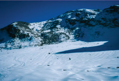
Day 06: Odari to Bali col camp
Altitude: 4,600m/15,100ft.
Altitude difference: 600m/2,000ft.
Trekking: 5km, 6-7 Hours
Technical ascent and steep.
Walk on a mountain ridge.
There is no water source.
Even though today's trek is only 3.25 kilometres long, it is still difficult. This is due to the steep incline that must be climbed. You must carefully navigate a 60-degree slanted mountain ridge filled with loose gravel. Can you believe you'll be camping overnight at an incredible elevation of 15,348 feet? There has been a significant drop in temperature, which may cause difficulty. Keep yourself active and hydrated by drinking plenty of water. This will lower your chances of getting Acute Mountain Sickness (AMS).
The main attraction of the day is camping in nature's purest bounty under a gleaming star-lit sky.
Day 07: Bali Col camp to Lower Dhamni via Bali Pass
Altitude: Bali Pass 4,950m/16.200ft, LowarDhamni 3400m/11.100ft
Altitude difference: -1,200m/4,000ft.
Trekking: 14km, 10- 11 hours
A steep and technical ascent for approximately 1-1.5 hours to reach the Pass.
Summit View: Bandarpoonch (Black Peak), Kalanag (Black Peak), Ruinsara, Yamunotri, and Ruinsara side. This is the logical route to Saptarishikund.
Half of the trek begins after reaching Bali Pass.
Because the path after the pass can be confusing, it is important to stay with a Trek
Bring enough water to your campsite (Bali col).
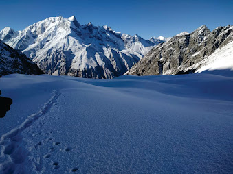
It's D Day today! It is, without a doubt, the most thrilling and exciting day of the entire journey. It is also the most difficult trek route on the Bali Pass trek itinerary. Today, you will cross the magnificent Bali Pass, which is perched at a staggering altitude of 16,240 feet.
You begin your journey early in the morning. It takes 2 to 3 hours to reach the Bali Pass from the base camp. The trekking trail leading to the Pass is snow-covered. To get to the Pass, you must walk on moraine ridge and boulder, snowy patches, and steep hikes. Day 5's learning techniques will come in handy when navigating this difficult trail.
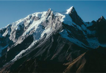
When you step onto the rock-strewn Bali Pass, all of your fatigue from the day vanishes in an instant. The Bali Pass clearly separates the Yamunotri Valley and Tons Valley. From the top, you can also see the sacred SwargaRohini peak, Kala Nag, Bandar Poonch, and Ruinsara Gad. There are also brief glimpses of the frozen Sapta Rishi Kund.
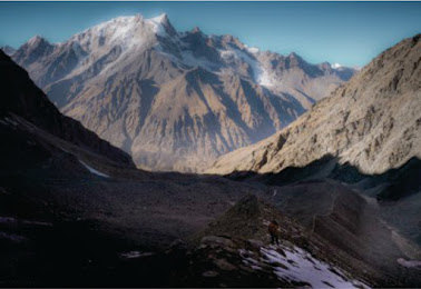
Enjoy the scenery and take some picture-perfect photos before heading down. It's a treacherous descent through an Alpine zone of scree and large gravel stones. After navigating this perilous path, you arrive at Upper Dhamni, where you rest for a while. Lower Dhamni, the base camp at an elevation of 11,204 feet, is reached on the final lap of the trek. The trek from Upper Dhamni to Lower Dhamni is a little perplexing. It is recommended that you remain with your team. Camps are where you'll spend the night.
Day 08: Lower Dhamni - JaankiChatti& drive to Dehradun
Altitude: 2,600m/8,500ft. (JaankiChatti)
Altitude difference: 800m/2600ft.
Trekking: 8km, 4-5 Hours
A well-defined and easy trail.
Water source sufficient.
170km, 7hours drive.
Today is the final day of the journey. The 4.5-kilometre trek from Lower Dhamni to Yamunotri includes a few gentle ascents. It takes 1.5 hours to complete this trail, which begins in the woods and eventually leads to a paved path. The holy place of Yamunotri is a treat in and of itself once you arrive. You pay your respects at the well-known Yamunotri Temple and Sapta Rishi Kund, as well as bathe in the hot Sulphur Springs. From here, take the 5 km pilgrimage route to JaankiChatti. On the same day, a cab ride from JaankiChatti to Dehradun.
Is the Bali Pass Trek Recommended for Beginners
Because the Bali Pass trek takes you to an elevation of close to 16,250 ft, it is strongly advised that you have prior trekking experience for this trek. This difficult altitude trek necessitates proper training; it is recommended that you train for 2 to 3 months prior to embarking on this trek. As a trekker, you will need technical equipment such as crampons and rope to complete this trek.
Because of the high altitude and changing weather conditions, proper acclimatisation is required; it is best if you arrive 1 to 2 days before your hike begins.
Difficulty Level of Trek
The Bali Pass walk is regarded as challenging. The walking trail is peppered with difficult terrain, rocky roads, and steep ascents and descents. As a result, you must be extra cautious when taking each step along the path.
This walk lasts five days. Every day, you should walk 7 to 8 kilometres. It necessitates both physical and mental preparation. This trek necessitates prior preparation such as practising long-distance walking, exercising, and meditating to achieve mental and physical equilibrium.
This walk is recognised as one of the Himalayas' most unknown and difficult hikes. The route becomes tougher with each step. The trails are incredibly small and perilous, and this climb necessitates lengthy hours of trudging on glaciers. You must be extremely vigilant and cautious in all of your actions.
Before embarking on the Bali Pass climb, you must have prior trekking experience. Go on this trip with a qualified trek guide who is familiar with the trek pathways for a safer trekking experience.

Best Time To Visit Bali Pass
Bali Pass in Summer Season
The summer season (May to June) is perfect for visiting Bali Pass. The weather remains good during these months, with a clear sky. In the highlands, the forests and meadows grow rich green, and flowers bloom. Because of the clear skies throughout the summer, you will be able to enjoy unimpeded views of the Himalayan peaks.
As summer approaches in May, the glaciers may also produce frosty or melting snow. During the day, the temperature remains warm, ranging from 200 to 250 degrees Celsius. It begins to cool off at night, and the temperature drops to 50°C or even 00°C. Woollens should be worn at all times.
Bali Pass in Autumn Season
The Bali Pass welcomes trekkers with fresh and vibrant vistas during the months of September and October. During the autumn season, the entire environment changes colours and becomes clothed in bright shades of yellow, brown, and orange. The month of September is distinguished by dried autumnal leaves and a charming ambience, but the month of October marks the beginning of the year's first snowfall.
This month, snow fans may satiate their hunger for thrills and adventure in the snow. The temperature is fairly low in the post-monsoon months. Temperatures around Ruinsara Lake frequently drop to 0 degrees Celsius or below. To defend oneself from the bitter cold throughout the month of October, you will need to dress in several layers.
Bali Pass Weather/Temperature
Bali Pass is snow-covered till the beginning of May. As the temperatures increase, the snow melts and the trails become frosty and icy.
During the summer months of May and June, daytime temperatures can range from 18 to 25 degrees Celsius, with nighttime temperatures ranging from 0 to 5 degrees Celsius.
Temperatures begin to plummet in the fall months of September and October and can range from 0 degrees to sub-zero temperatures at higher altitudes.
How to Get to Basecamp
The Bali Pass Trek's basecamp is in Sankri, which is around 190 kilometres from Dehradun. The basecamp, Sankri, is an 8-hour trip from Dehradun.
By Road
You can catch a bus to Dehradun from Delhi's Kashmiri Gate bus station. The distance between Delhi and Dehradun is around 256 kilometres, and it will take approximately 6 hours to travel by bus. Direct buses go from Dehradun to Sankri, however, you should be in Dehradun early in the morning because bus services to Sankri are only accessible till 8 a.m. It will take you 8 to 9 hours to go 200 kilometres from Dehradun to Sankri.
By Train
The nearest railway station to Bali Pass is Dehradun. There are several trains that run from Delhi to Dehradun, including the DEHRADUN SHTADI, DDN JANSHTBDI, and DEHRADUN EXPRESS. When you arrive at Dehradun train station, you can easily find buses and cabs to Sankri Village. There are numerous trains available from Haridwar to Dehradun. It takes around 1 hour 30 minutes to travel 51 kilometres from Haridwar to Dehradun railway station. You may take buses or taxis to Sankri Village from Dehradun train station.
By Air
The nearest airport for the Bali Pass hike is Dehradun's Jolly Grant Airport. To get to Jolly Grant, you must arrange a cab, which will take approximately 45 minutes. In the morning, shared cabs, private cabs, or local buses will transport you from Dehradun to Sankri Village. You can also arrange private cabs from Jolly Grant airport directly to Sankri Village.
Bali Pass Trek Route With The Attractions
The hike begins with a beautiful journey from Dehradun to Sankri Village. The Govind Wildlife Sanctuary encompasses Sankri Village in the Uttarkashi district. The 8-hour drive takes you past scenic areas such as Kempty Falls, Mussorie, and Nainbagh. These locations are peppered with magnificent Himalayan peaks. The evening starry sky against the backdrop of the towering density of peaks glittering with moonlight will be a visual pleasure when you arrive in Sankri.
You'll need to drive another 12 kilometres from Sankri to Taluka. This excursion will take you through gushing streams and bamboo and deodar trees. You must begin your adventure by walking from Taluka. You must go through gravel trails that lead to a river bed. You must walk along the tranquil Supin River from here.
Trekking up with the soothing sound of the river flowing by as a companion will make your journey even more memorable. This hiking path will also take you to Ghangad hamlet, which is known for its wooden architecture. After a hard hike, you will arrive at Seema, a camping place where you may rest for the night.
You'll have to make your way up to DebshuBugyal by trudging along the Supin River. The path to DebshuBugyal is fairly steep and has large rocks. You'll have to be very careful and watch your step. DebshuBugyal is large pastureland that stretches for up to 2 kilometres. From here, you will have breathtaking views of the Black Peak, which will compel you to pause and reflect on the majesty of God's works. The route upwards becomes steeper and slicker from here.
This hike will take you to the much-anticipated Ruinsara Lake. On foot, it will take roughly 3 to 4 hours to reach the water body. The approach to the Lake offers views of the dazzling glaciers and murmuring streams. The campground will be situated between the Supin River and Ruinsara Lake. This campground is surrounded by wavy meadows and woody woodlands, with a panoramic view of the snow-capped mountains all around.
The most visible mountains from here are Kala Nag, Bandarpoonch, DhumdharKhai, and White Peak. The Yamunotri Temple is fairly close to this campsite. Spend the night and discover this fascinating locale! The distance between Ruinsara Tal and Odari is only 4 kilometres. The walk route winds through lush forests and gushing rivulets. As you approach Odari, you will come across a rock cave from which Odari (which means cave) got his name. From this cave, you may get a good look at Swargarohini Peak.
It will be challenging to go to the Bali camp from Odari. The trip way is quite dangerous, and slog up the increasingly rocky terrain requires patience and perseverance. As a result, you must continually rest in order to adjust your body to the climatic conditions. You'll be enthralled by the top.
On this day, you will travel through the Bali Pass and then to Lower Dhamni. After 3 to 4 hours of difficult ascents, you will arrive at the Pass's apex. The Pass measures 10 feet long by 30 feet wide. When you reach the summit, you will feel as if you are on top of the world! You will have a spectacular view of the Bandarpooch, Swargarohini, and Garhwal Peaks from this vantage point.
The view of the Yamnotri Valley on the right is worth catching. It is incredibly difficult and tricky to descend from this location. It is frequently strained as a result of the melting layers of snow. To avoid mishaps, adhere to your trek guide's instructions and use extreme caution. Come down to your tents slowly and carefully and rest. The journey comes to an end when you leave and begin to descend.
The course is rather easy, with only minor descents and ascents. When you get in Yamunotri, you can visit the Yamunotri temple and pay your respects at Sapta Rishi Kund. You'll have to walk another 5 kilometres to get to Jaan Ki Chatti. When you arrive at Jaan Ki Chatti, take a cab back to Dehradun.
Comments
Post a Comment
If you have any doubt please let me know