Valley of Flowers Trek About Valley of Flowers The Valley of Flowers lives up to its name, with an endless supply of flowers in full bloom. The journey could even be renamed a floral fairytale romance! The Valley of Flowers' unique landscape is like a dream come true: an exquisite valley bejewelled with a never-ending stretch of flowers. Between the rocky mountain ranges of Zanskar and the Great Himalayas are lovely meadows studded with indigenous alpine flora. The area, which is a UNESCO World Heritage site, was designated as a national park in 1982. The endless stretch of gorgeous vegetation, dotted with colourful blossoms of pink, yellow, purple, red, blue, and orange hues, is the highlight of this excursion. Throughout the hike, the fragrant scent of the carpeting flowers entices you. Botanists, flower lovers, bird watchers, wildlife photographers, hikers, environment enthusiasts, and adventure seekers from all over the world are drawn to the valley's unspoiled beauty. It...
Kedar Tal Lake Trek, Uttarakhand
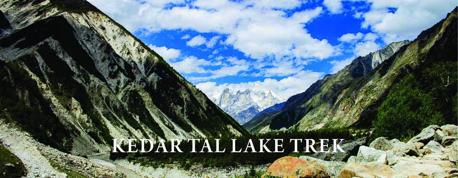
The Complete Guide To Kedartal Trek
A Rare Adventure Among Big Mountains
If seeing mountains in person isn't exciting enough, catching them in the reflection of a lake is. Kedartal is an emerald lake that reflects the Thalaysagar peak perfectly. Thalaysagar, after Shivling peak, is regarded as the most beautiful summit. Surprisingly, both of them are located in the Gangotri range. This is the second trek departing from Gangotri after Gomukh Tapovan. As a result, it is not lacking in tempting views.
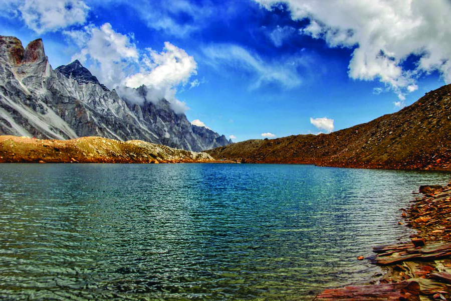
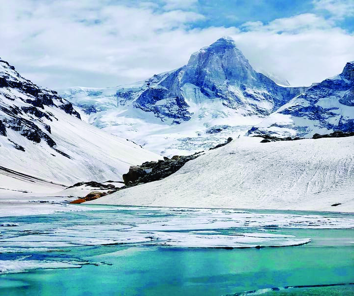
Kedartal, at 15,485 feet above sea level, is one of the world's most spectacular glacier lakes. It gets its water from the Thalaysagar and Brighupanth peaks' melting snow. This lake is the finest site to see the grandeur of massive peaks up close. Manda, Bhagirathi, Gangotri, Bhrigupanth, Mt. Meru, and Thalaysagar are among the summits. The lake blends in perfectly with the arid terrain of the higher Himalayas. It's like a lotus in blossom in the mud! Except for the muck, there are black-white mountains rising here.

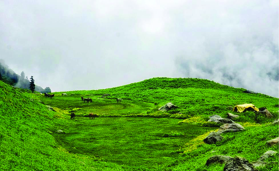
When you go on the Kedar Tal trek, you will be able to enjoy the best of Gangotri's beauty. The route is not for the inexperienced, especially in the winter. The summer trek, on the other hand, is excellent, with plenty of floral beauty on both sides of the trek route. Aspiring meadows on both sides of the route with excellent art and craft, naturally maintained by nature, will greet you at every turn. As a result, even though the route is difficult and steep, you will never tyre. Kedartal, the Kedar Ganga's extension, has enough mythological merits, though that is well covered with the utmost care from nature's god alone. Sides.she is guarding the precious myths in her air, flora, and snow-covered hilltops. Indeed, the snow-covered peaks on all sides will appear to protect the Bhagirath Shila from all sides.
The trek begins in Uttarkashi. The trek route until Gangotri is extremely difficult, with numerous turns, climbs, and rocky surfaces. The meadows and the shades of nature's unparalleled beauty will never allow you to feel tired. The route to Bhoj Kharak and from there to Kedartal Lake is rich in flora. When you visit heaven in the autumn, you will be struck by its beauty and awe. Outstanding lake and ridge views entice photographers in the same way that flower pollen grains entice bees. Excellent natural backdrop demonstrates how much motherly affection she has.
Triund Trek an amazing trek near Dharamshala Himachal Pradesh
The scenery along the way has been breathtaking in every way. As you progress through the levels, you will realise that your stock of words is at its lowest point, unable to adequately describe nature's splendour. The meadows and alpine forest that you will encounter on the trek route will provide you with the refreshment that you require from nature's mother. She is always willing to shower you with love and blessings – sometimes as nature, sometimes as the protector of ancient mythological holiness. When you arrive at Lake Kedartal, you will feel as if you have arrived in heaven.
The lake is thought to be Lord Shiva's gift to the Ganges as a token of blessings for her arrival on Earth. Aside from Gangotri and its mythological stories, there is also the inspirational rock known as Bhagirath Shila, where Bhagirath sat and prayed for Lord Shiva's blessings. The panoramic view of the area, particularly the ridge presented by Shiva, will simply remove all words and senses from your heart. After experiencing the breathtaking beauty of the location, you will feel blessed to be able to reach heaven even in this body. Its essence, affluence, and odour will simply transport you back to your childhood love of nature.The spirits who reach this place, who are beyond all mythological understandings, feel the touch of god. So, heaven it is, and you will be exploring it very soon.
Also read about the Rupin Pass Trek to explore the trek CLICK HERE
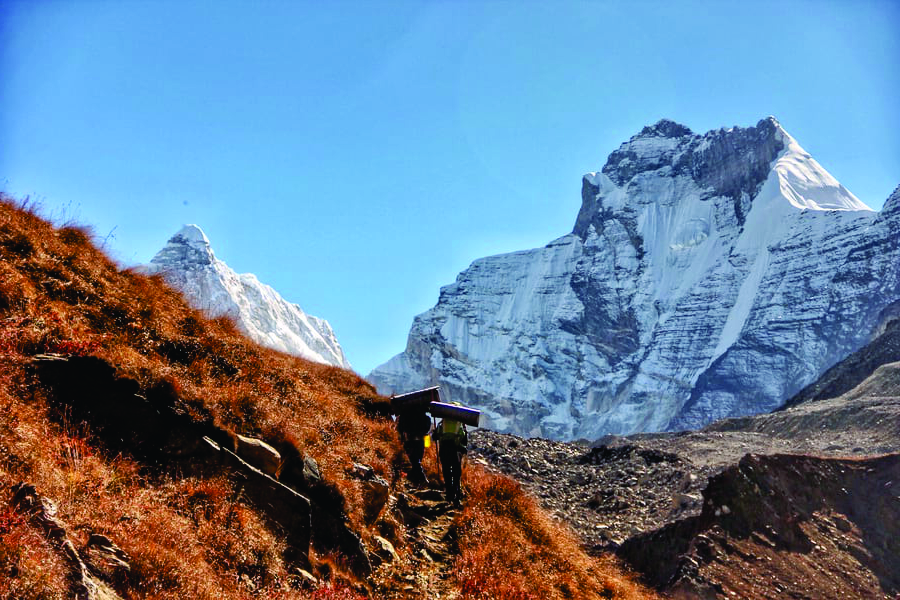
Due to the existence of a rocky trail from day one, this journey is considered challenging. The path is narrow and steep, with a lot of scree, dust, and rocks. The first day of trekking, in fact, takes you via a narrow ledge on a 60-degree rock wall. And the complexity continues to rise. Until the final high slope at the peak. The walk also passes through beautiful meadows and brilliant blooms. The trail has it all, with a few stream crossings over Kedar Ganga.
If you are a seasoned hiker looking for a once-in-a-lifetime trip. Then the Kedartal trek is for you!
U can also read this the Bali Pass Trek
Trek Overview

The Kedartal Trek is one of the most popular treks in India, offering spectacular views of the mountains to those who participate. The walk is not for the faint of heart; it is challenging, and only those with tremendous physical endurance are capable of participating. The trekking track leads visitors through some of the most beautiful pine forests in the world. It is also the journey that offers trekkers the chance to see bharals or blue sheep. The moderate to challenging trekking track adds to the adventure, especially for young people who wish to feel the rush of adrenaline coursing through their veins. The walk lasts an average of 7 days, so it's a terrific method to satisfy one's desire for adventure. The walk lasts an average of 7 days, so it's a terrific method to satisfy one's desire for adventure.
Click Here to know about The Brahama Tal Trek.
About Kedartal Lake
The Kedartal Lake, commonly known as "Shiva's Lake," is a glacier lake located at an elevation of 15,580 feet (4,750 metres) above sea level. It is situated in the Himalayan area of Gharwal. The lake is most notable for being the source of the Kedar Ganga, and it is mostly fed by snowfall from adjacent peaks such as Meru, Thalay Sagar, and others. This is a holy lake for Hindus since it is believed that Kedar Ganga originated from Shiva and dropped to earth as a result of Bhagirath. The lake is located near Gangotri, and many people trek there each year to admire its beauty.
The descent is extremely steep, making it a challenging hike, but it offers a spectacular view of the local flora and fauna. The difficulties of the Kedartal walk should be considered before signing up for it.
The Kedartal trek Uttarkhand begins from the Gangotri base camp, with the first day's trek taking about 4 to 5 hours on average. you will travel to Kedar Kharak on the second day, which takes around 5 hours on average and requires passing over high terrain. A 5-hour hike on the third day finally brings a person to the Kedartal Lake, where you can rest before beginning the descent the next day. Take help from a Kedartal trek route map to know more.
Buran Ghati Pass Trek to know more click here

A Quick Glance to Some of the Amazing Facts of Kedartal Lake Trek:
Region: Garwhal Region of the Indian Himalayas, Uttarkhand
Trek Altitude: 4,750M
Trek Difficulty Level: Moderate to Difficult
Trek Duration: 6 Days
Distance: 32 KM
Start Point: Gangotri
End Point: Gangotri
Base Camp: Gangotri
Temperature: During the summer months, the average temperature during the day is 10-12 degrees Celsius and the average temperature at night is 6-8 degrees Celsius. People who are visiting after monsoons can find the temperatures dipping to -2 degrees Celsius at night. During the harsh winters, the temperature can even fall to -20 degrees Celsius.
Nearest Railway Station: Haridwar Railway Station
Nearest Airport: Jolly Grant Airport, Dehradun
Last ATM: Take out your money at Haridwar.
Day 1: Haridwar to Gangotri
You can travel from Haridwar to Gangotri. The journey from Haridwar to Gangotri takes approximately ten hours. Because Gangotri is the starting point for your journey, you should take your time in the hotel to prepare for the walk. The Gangotri temple is a major tourist attraction. The total distance between Hardiwar to Gangotri is around 289 kilometres. Of course, you can visit Gangotri, which is 3,415 metres above sea level. For many individuals, the journey from Delhi to Kedartal is a popular one. You must prepare for the forthcoming Kedartal Weather here. This journey will get you to Gangotri, the beginning point for the Kedartal Trek.Gangotri is both a scenic and holy destination for Hindu worshippers, so expect a crowd, especially during the Char Dham pilgrimage in the months of May and June, which are also the best months for Kedartal Trekking. From here, you can sense the altitude of the Kedartal.
Click Here to know about the most beautiful trek Roop Kund Trek
Day 2: Gangotri to Bhoj Kharak
After breakfast on the second day, you will begin the trek to Bhoj Kharak, which will take you to a height of 3,780 metres above sea level and will take approximately 4 to 5 hours depending on your fitness. The trail is approximately 8 kilometres long. The trail follows the Kedar Ganga River and passes through birch and cedar woodlands along the way. This is an extremely challenging climb, so folks should plan accordingly. The trek's panoramic beauty is breathtaking, as it offers a natural view of various waterfalls and mountains. It gains 932 metres in altitude, and you must be prepared to navigate rugged terrain.. At Kedartal Trek Best Time this trek provides a marvellous view
When you cross the Bhagirathi River, you must choose a woodland trail to begin your walk to Bhoj Kharak. You must be cautious since the valley narrows along the route, and you may experience shortness, which is normal. The fir trees are replaced by birch trees. During the walk, you will come upon the spider wall, which only gives a limited path that must be carefully navigated.
At Bhoj Kharak, the camp is located on a flat piece of land. To stay hydrated during the walk, you'll need to take frequent sips of water. Take a look at the Kedartal trek route map to get a better sense of the paths.

Beas Kund Trek is an amazing trek Click Here to know more
Day 3: Bhoj Kharak to Kedar Kharak
The following day, you will begin your journey to Kedar Kharak, which is 4,270 metres above sea level. The Kedartal trip's hard to track makes the 4-kilometre journey take about 5 hours to complete. Due to the terrain, you will be fatigued by the finish. The birch trees and lovely meadows make up for it, and you get to camp on a meadow in the lovely Kedar Kharak and enjoy a good hot meal at the end.
The Kedartal hike begins in the Bhoj forest and leads to meadows that are particularly beautiful in the autumn. On the route, you'll pass by the Bhrigupanth, which is stunning. You might see blue sheep, goral, Himalayan Black bear, and other animals along the road. As you climb the trail, you'll see a thin layer of frost. The sunset at Kedar Kharak is very famous.

Harki Dun Ruinsara Tal Trek to know more click here
Day 4: Kedar Kharak to Kedar Tal and back to Kedar Kharak
The Kedartal Lake is the end objective of this walk. The height rise is 4,750 metres, and this is the most challenging section of the walk, which takes around 8 hours to complete because you must return to Kedar Kharak. The entire path is littered with boulders, making it a challenging journey that requires proper footwear. Our guide will take you to the adjacent Thalay Sagar Peak after you arrive at Kedar Tal. Because you will be removed from the city's pollution, you will be among some of nature's most stunning masterpieces. Camping at Kedar Kharak will be a once-in-a-lifetime experience.
The walk is primarily desolate in this section, and it is rather difficult. Weather can also be unpredictably unexpected at times. Because there are no water sources nearby, you will need to bring your own water; we recommend bringing at least 2 litres. The Tal or the lake is indicated by cairns or tiny mounds of rock. At the Kedar Tal Lake, which has a lovely emerald green hue, you can expect frigid Kedartal Weather. The route map for the Kedartal trek is quite useful throughout the hike.

The Bhrighu Lake Trek to know more click here
Day 5: Kedar Kharak to Bhoj Kharak
The journey from Kedar Kharak to Bhoj Kharak takes around 4 hours, and you can sleep in Bhoj Kharak and explore the nearby trails.
Day 6: Bhoj Kharak to Gangotri and drive back to Haridwar
The next day, you must begin your walk to Gangotri, which served as your base camp for the Kedartal trip. It will take about 4 hours, and you will be met by car at Gangotri. It will transport you to Haridwar. This concludes our Kedartal trek itinerary.

Kedartal Trek Difficulty
When preparing for a trek, it is critical to estimate the level of difficulty before embarking on it. The difficulty level of the Kedartal hike is rated as moderate to high. It is not for people who are about to go on their first expedition. The lake is one of the highest glacial lakes in Uttarakhand, and getting there requires navigating challenging terrain. To reach Kedartal, hikers must cross through pine forests, high-elevation pastures, and sliding zones. When going on a journey, one should pack appropriately for the weather as well as meet the various needs.
CLICK HERE To Explore The Beauty of The Kedarkantha Tal Trek
Best Time to Visit Kedartal
There are two optimum periods to go Kedartal trekking. The first lasts from May to June, during the summer months, and the second from September to mid-October, during the post-monsoon months. These months are the best time to visit Kedartal Trek since the weather is beautiful and one may have a clear glimpse of their trekking track. During the post-monsoon season, the area transforms into a haven. The walk is blocked in the winter because to the rough terrain, severe snowfall, and sub-zero temperatures, which are not ideal for survival.
The Most Beautiful Trek in Himachal Pradesh Hampta Pass Trek To know More Click Here.
Kedartal Temperature
Summer Months from May to June: 10 to 12 degrees Celsius during Daytime and 6 to 8 degrees during Nighttime
Monsoon Months from July to August: 14 to 18 degrees Celsius during Daytime and 6 to 10 degrees during Nighttime
Post-Monsoon Months from September to October: 10 to 9 degrees Celsius during Daytime and 0 to -2 during Nighttime
Winter Months from November to April: -6 to -4 degrees Celsius during Daytime and –20 to -11 degrees Celsius during Nighttime.
Comments
Post a Comment
If you have any doubt please let me know